Entremont, Haute-Savoie
| Entremont | ||
|---|---|---|
|
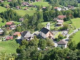
An aerial view of Entremont | ||
| ||
 Entremont | ||
|
Location within Auvergne-Rhône-Alpes region  Entremont | ||
| Coordinates: 45°57′27″N 6°23′23″E / 45.9575°N 6.3897°ECoordinates: 45°57′27″N 6°23′23″E / 45.9575°N 6.3897°E | ||
| Country | France | |
| Region | Auvergne-Rhône-Alpes | |
| Department | Haute-Savoie | |
| Arrondissement | Bonneville | |
| Canton | Bonneville | |
| Intercommunality | Communauté de communes des Vallées de Thônes | |
| Government | ||
| • Mayor (2008–2014) | Gilles Maistre | |
| Area1 | 18.35 km2 (7.08 sq mi) | |
| Population (1999)2 | 462 | |
| • Density | 25/km2 (65/sq mi) | |
| Time zone | CET (UTC+1) | |
| • Summer (DST) | CEST (UTC+2) | |
| INSEE/Postal code | 74110 / 74130 | |
| Elevation | 755–2,019 m (2,477–6,624 ft) | |
|
1 French Land Register data, which excludes lakes, ponds, glaciers > 1 km² (0.386 sq mi or 247 acres) and river estuaries. 2 Population without double counting: residents of multiple communes (e.g., students and military personnel) only counted once. | ||

Entremont is a commune in the Haute-Savoie department in the Auvergne-Rhône-Alpes region in south-eastern France.
See also
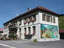
Entremont city hall
References
| Wikimedia Commons has media related to Entremont, Haute-Savoie. |
This article is issued from Wikipedia - version of the 10/28/2016. The text is available under the Creative Commons Attribution/Share Alike but additional terms may apply for the media files.