Poisy
| Poisy | ||
|---|---|---|
|
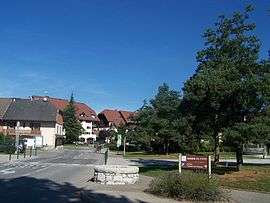
A view of the centre of Poisy | ||
| ||
 Poisy | ||
|
Location within Auvergne-Rhône-Alpes region  Poisy | ||
| Coordinates: 45°55′18″N 6°03′44″E / 45.9216°N 06.0622°ECoordinates: 45°55′18″N 6°03′44″E / 45.9216°N 06.0622°E | ||
| Country | France | |
| Region | Auvergne-Rhône-Alpes | |
| Department | Haute-Savoie | |
| Arrondissement | Annecy | |
| Canton | Annecy-Nord-Ouest | |
| Intercommunality | agglomération d'Annecy | |
| Government | ||
| • Mayor (2008–2014) | Pierre Bruyère | |
| Area1 | 11.33 km2 (4.37 sq mi) | |
| Population (2006)2 | 6,532 | |
| • Density | 580/km2 (1,500/sq mi) | |
| • Urban | 139,693 | |
| Time zone | CET (UTC+1) | |
| • Summer (DST) | CEST (UTC+2) | |
| INSEE/Postal code | 74213 / 74330 | |
| Elevation | 384–675 m (1,260–2,215 ft) | |
| Website | Poisy.fr | |
|
1 French Land Register data, which excludes lakes, ponds, glaciers > 1 km² (0.386 sq mi or 247 acres) and river estuaries. 2 Population without double counting: residents of multiple communes (e.g., students and military personnel) only counted once. | ||

Poisy is a commune in the Haute-Savoie department in the Auvergne-Rhône-Alpes region in south-eastern France.
Geography
The Fier forms the commune's southern border.
See also
References
| Wikimedia Commons has media related to Poisy. |
This article is issued from Wikipedia - version of the 10/28/2016. The text is available under the Creative Commons Attribution/Share Alike but additional terms may apply for the media files.