Passy, Haute-Savoie
| Passy | ||
|---|---|---|
|
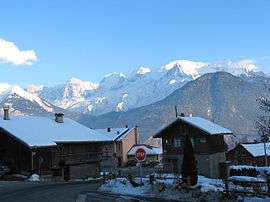
A view of Mont Blanc from the village | ||
| ||
 Passy | ||
|
Location within Auvergne-Rhône-Alpes region  Passy | ||
| Coordinates: 45°55′28″N 6°41′14″E / 45.9244°N 6.6872°ECoordinates: 45°55′28″N 6°41′14″E / 45.9244°N 6.6872°E | ||
| Country | France | |
| Region | Auvergne-Rhône-Alpes | |
| Department | Haute-Savoie | |
| Arrondissement | Arrondissement of Bonneville | |
| Canton | Canton of Saint-Gervais-les-Bains | |
| Intercommunality | SIVOM Pays du Mont-Blanc | |
| Government | ||
| • Mayor (2008–2014) | Gilles Petit-Jean Genaz | |
| Area1 | 80.03 km2 (30.90 sq mi) | |
| Population (2006)2 | 11,234 | |
| • Density | 140/km2 (360/sq mi) | |
| • Urban | 60,234 | |
| Time zone | CET (UTC+1) | |
| • Summer (DST) | CEST (UTC+2) | |
| INSEE/Postal code | 74208 / 74190 | |
| Elevation | 542–2,880 m (1,778–9,449 ft) | |
| Website | Ville-passy-mont-blanc.fr | |
|
1 French Land Register data, which excludes lakes, ponds, glaciers > 1 km² (0.386 sq mi or 247 acres) and river estuaries. 2 Population without double counting: residents of multiple communes (e.g., students and military personnel) only counted once. | ||

Passy is a commune in the Haute-Savoie department in the Auvergne-Rhône-Alpes region in south-eastern France.
Located there is the Sancellemoz sanatorium, where Professor Marie Curie died.
Lac Vert is located in the commune.
See also
References
External links
| Wikimedia Commons has media related to Passy. |
This article is issued from Wikipedia - version of the 10/28/2016. The text is available under the Creative Commons Attribution/Share Alike but additional terms may apply for the media files.