Les Clefs
| Les Clefs | ||
|---|---|---|
|
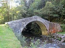
The "Roman bridge" | ||
| ||
 Les Clefs | ||
|
Location within Auvergne-Rhône-Alpes region  Les Clefs | ||
| Coordinates: 45°51′42″N 6°19′44″E / 45.8617°N 6.3289°ECoordinates: 45°51′42″N 6°19′44″E / 45.8617°N 6.3289°E | ||
| Country | France | |
| Region | Auvergne-Rhône-Alpes | |
| Department | Haute-Savoie | |
| Arrondissement | Annecy | |
| Canton | Thônes | |
| Intercommunality | Communauté de communes des Vallées de Thônes | |
| Government | ||
| • Mayor (2008–2014) | Martial Landais | |
| Area1 | 18.47 km2 (7.13 sq mi) | |
| Population (1999)2 | 472 | |
| • Density | 26/km2 (66/sq mi) | |
| Time zone | CET (UTC+1) | |
| • Summer (DST) | CEST (UTC+2) | |
| INSEE/Postal code | 74079 / 74230 | |
| Elevation | 670–2,351 m (2,198–7,713 ft) | |
|
1 French Land Register data, which excludes lakes, ponds, glaciers > 1 km² (0.386 sq mi or 247 acres) and river estuaries. 2 Population without double counting: residents of multiple communes (e.g., students and military personnel) only counted once. | ||

Les Clefs is a commune in the Haute-Savoie department in the Auvergne-Rhône-Alpes region in south-eastern France.
Geography
The Fier forms part of the commune's north-eastern border, then flows westward through the northern part of the commune.
See also
References
| Wikimedia Commons has media related to Les Clefs. |
This article is issued from Wikipedia - version of the 10/28/2016. The text is available under the Creative Commons Attribution/Share Alike but additional terms may apply for the media files.