Magland
| Magland | ||
|---|---|---|
|
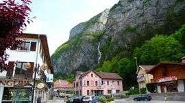
Magland and the waterfall | ||
| ||
 Magland | ||
|
Location within Auvergne-Rhône-Alpes region  Magland | ||
| Coordinates: 46°01′22″N 6°37′14″E / 46.0228°N 6.6206°ECoordinates: 46°01′22″N 6°37′14″E / 46.0228°N 6.6206°E | ||
| Country | France | |
| Region | Auvergne-Rhône-Alpes | |
| Department | Haute-Savoie | |
| Arrondissement | Arrondissement of Bonneville | |
| Canton | Canton of Sallanches | |
| Intercommunality | CC Cluses-Arve et Montagnes | |
| Government | ||
| • Mayor (2014–2020) | René Pouchot | |
| Area1 | 40.32 km2 (15.57 sq mi) | |
| Population (2012)2 | 3,202 | |
| • Density | 79/km2 (210/sq mi) | |
| Time zone | CET (UTC+1) | |
| • Summer (DST) | CEST (UTC+2) | |
| INSEE/Postal code | 74159 / 74300 | |
| Elevation | 483–2,649 m (1,585–8,691 ft) | |
| Website | Official website | |
|
1 French Land Register data, which excludes lakes, ponds, glaciers > 1 km² (0.386 sq mi or 247 acres) and river estuaries. 2 Population without double counting: residents of multiple communes (e.g., students and military personnel) only counted once. | ||
.svg.png)
Magland is a commune in the Haute-Savoie department in the Auvergne-Rhône-Alpes region in south-eastern France.
Geography
Magland is in the Vallée de l'Arve, between Cluses and Sallanches. There are several hamlets like Gravin, Balme, Oëx, Luth and belongs to the Canton of Sallanches.
Education
There are four schools in Magland: the primary school of the Chef-Lieu, of the Gravin, of the Moranche and a nursery school.
See also
Twin towns
References
| Wikimedia Commons has media related to Magland. |
This article is issued from Wikipedia - version of the 10/28/2016. The text is available under the Creative Commons Attribution/Share Alike but additional terms may apply for the media files.