Bertangles
| Bertangles | |
|---|---|
 Bertangles | |
|
Location within Hauts-de-France region  Bertangles | |
| Coordinates: 49°58′15″N 2°18′02″E / 49.9708°N 2.3006°ECoordinates: 49°58′15″N 2°18′02″E / 49.9708°N 2.3006°E | |
| Country | France |
| Region | Hauts-de-France |
| Department | Somme |
| Arrondissement | Amiens |
| Canton | Villers-Bocage |
| Intercommunality | Amiens Métropole |
| Government | |
| • Mayor (2001–2008) | Joseph Debart |
| Area1 | 8.57 km2 (3.31 sq mi) |
| Population (2006)2 | 620 |
| • Density | 72/km2 (190/sq mi) |
| Time zone | CET (UTC+1) |
| • Summer (DST) | CEST (UTC+2) |
| INSEE/Postal code | 80092 / 80260 |
| Elevation |
51–131 m (167–430 ft) (avg. 59 m or 194 ft) |
|
1 French Land Register data, which excludes lakes, ponds, glaciers > 1 km² (0.386 sq mi or 247 acres) and river estuaries. 2 Population without double counting: residents of multiple communes (e.g., students and military personnel) only counted once. | |
Bertangles is a commune in the Somme department in Hauts-de-France in northern France.
Geography
Bertangles is situated on the D97 road, just off the N25, 3 miles (5 km) north of Amiens. A farming area with extensive woodland and a grand chateau.
Population
| Year | 1962 | 1968 | 1975 | 1982 | 1990 | 1999 | 2006 |
|---|---|---|---|---|---|---|---|
| Population | 284 | 287 | 387 | 646 | 700 | 654 | 620 |
| From the year 1962 on: No double counting—residents of multiple communes (e.g. students and military personnel) are counted only once. | |||||||
Places of interest
- The 18th-century château, constructed by Louis-Joseph Clermont-Tonnerre from 1730 to 1734, replacing the medieval structure, itself rebuilt in the 16th century, after being burned by the Spaniards in 1597. An old gateway is all that remains of the older building, which gives access to the farm, to the west. In August 1930, a fire destroyed the interior of the château, particularly the woodwork. All was remade in the same style in subsequent years. The stairway and ramp of wrought iron have also been restored.
The chateau was also used as Headquarters by the Australian Corps prior to the Battle of Amiens in August 1918
Personalities
- Rittmeister Manfred Freiherr von Richthofen, the Red Baron, was buried with military honours by the Australian Flying Corps in the cemetery some distance from the village on 22 April 1918, but exhumed after the end of World War I and reburied first in the German military cemetery of Fricourt (Somme), then by his brother in Berlin. After the Second World War his remains were transferred to Wiesbaden (in 1975).
See also
References
Bibliography
- « Canton of Villers-Bocage - Châteaux et fermes - N° 182 - Coll. Itinéraires du patrimoine » - Textes de Judith Förstel - 1999 - ISBN 2-906340-40-5
- « Dictionnaire historique et archéologique de Picardie - Arrondissement of Amiens - Tome III » - E. Héren et L. Ledieu - 1919
- « Dictionnaire des châteaux de France : Artois, Flandre, Hainaut, Picardie » - J. Thiebaut - 1978
- « Églises, châteaux, beffrois et hôtels-de-ville les plus remarquables de la Picardie et de l'Artois » - A. Goze - 1849
- « La décoration sculptée des façades du château de Bertangles » - François de Clermont-Tonnerre - dans Bulletin de la Société des Antiquaires de Picardie - Tome 76 - 1976
- « Un grand artiste du fer : Vivarais » - J. Foucart-Borville - dans Bulletin de la Société des Antiquaires de Picardie - 3e trim. 1980 (à propos de l'histoire de la grille d'honneur)
-
_1.jpg)
Pillars on the main gate
-
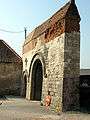
The gate to the medieval château
-
_1.jpg)
The Dovecote
-
_1.jpg)
The church
External links
| Wikimedia Commons has media related to Bertangles. |
- Bertangles on the Quid site (French)
- Bertangles on the map of France (French)
- Bertangles on Mapquest
This article is issued from Wikipedia - version of the 11/8/2016. The text is available under the Creative Commons Attribution/Share Alike but additional terms may apply for the media files.