Folleville, Somme
| Folleville | |
|---|---|
 | |
 Folleville | |
|
Location within Hauts-de-France region  Folleville | |
| Coordinates: 49°40′37″N 2°21′58″E / 49.6769°N 2.3661°ECoordinates: 49°40′37″N 2°21′58″E / 49.6769°N 2.3661°E | |
| Country | France |
| Region | Hauts-de-France |
| Department | Somme |
| Arrondissement | Montdidier |
| Canton | Ailly-sur-Noye |
| Intercommunality | Val de Noye |
| Government | |
| • Mayor (2001–2008) | Pierre Michelin |
| Area1 | 6.09 km2 (2.35 sq mi) |
| Population (2006)2 | 127 |
| • Density | 21/km2 (54/sq mi) |
| Time zone | CET (UTC+1) |
| • Summer (DST) | CEST (UTC+2) |
| INSEE/Postal code | 80321 / 80250 |
| Elevation |
62–158 m (203–518 ft) (avg. 146 m or 479 ft) |
|
1 French Land Register data, which excludes lakes, ponds, glaciers > 1 km² (0.386 sq mi or 247 acres) and river estuaries. 2 Population without double counting: residents of multiple communes (e.g., students and military personnel) only counted once. | |
Folleville is a commune in the Somme department in Hauts-de-France in northern France.
Geography
Folleville is situated on the D109 road, about 15 miles (24 km) south of Amiens.
Population
| Year | 1962 | 1968 | 1975 | 1982 | 1990 | 1999 | 2006 |
|---|---|---|---|---|---|---|---|
| Population | 52 | 73 | 46 | 62 | 63 | 72 | 127 |
| From the year 1962 on: No double counting—residents of multiple communes (e.g. students and military personnel) are counted only once. | |||||||
Places of interest
- Chateau de Folleville (14th century)
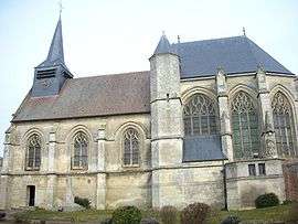
- Church of Saint-Jacques-Le-Majeur et Saint-Jean-Baptiste
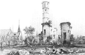
The church and the ruins of the château in 1617[1]
See also
References
Bibliography
- Pierre Michelin, Folleville. La fin du Moyen Âge et les premières formes de la modernité (1519–1617), préface de Jean Estienne, Amiens : Mémoires de la Société des Antiquaires de Picardie - tome 56, 2000, 398 p. ISBN 2-902829-04-3
- Georges Durand, "Les Lannoy, Folleville et l'art italien dans le Nord de la France", in Eugène Lefèbvre-Pontalis (dir.), Le Bulletin Monumental, tome 70, 1906.
External links
| Wikimedia Commons has media related to Folleville, Somme. |
This article is issued from Wikipedia - version of the 11/8/2016. The text is available under the Creative Commons Attribution/Share Alike but additional terms may apply for the media files.