Fieffes-Montrelet
| Fieffes-Montrelet | |
|---|---|
 | |
 Fieffes-Montrelet | |
|
Location within Hauts-de-France region  Fieffes-Montrelet | |
| Coordinates: 50°05′12″N 2°13′51″E / 50.0867°N 2.2308°ECoordinates: 50°05′12″N 2°13′51″E / 50.0867°N 2.2308°E | |
| Country | France |
| Region | Hauts-de-France |
| Department | Somme |
| Arrondissement | Amiens |
| Canton | Domart-en-Ponthieu |
| Intercommunality | Bernavillois |
| Government | |
| • Mayor (2001–2008) | Pierre Danvin |
| Area1 | 9.68 km2 (3.74 sq mi) |
| Population (2006)2 | 313 |
| • Density | 32/km2 (84/sq mi) |
| Time zone | CET (UTC+1) |
| • Summer (DST) | CEST (UTC+2) |
| INSEE/Postal code | 80566 / 80670 |
| Elevation |
63–147 m (207–482 ft) (avg. 98 m or 322 ft) |
|
1 French Land Register data, which excludes lakes, ponds, glaciers > 1 km² (0.386 sq mi or 247 acres) and river estuaries. 2 Population without double counting: residents of multiple communes (e.g., students and military personnel) only counted once. | |
Fieffes-Montrelet is a commune in the Somme department in Hauts-de-France in northern France.
Geography
The communes is situated on the D49 road, some 20 miles (32 km) east of Abbeville.
History
In 1975, the two communes of Fieffes and Montrelet were united to create a single administrative entity.
Population
| Year | 1962 | 1968 | 1975 | 1982 | 1990 | 1999 | 2006 |
|---|---|---|---|---|---|---|---|
| Population | 267 | 306 | 274 | 279 | 291 | 299 | 313 |
| From the year 1962 on: No double counting—residents of multiple communes (e.g. students and military personnel) are counted only once. | |||||||
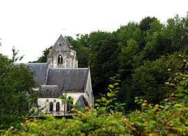
Places of interest
- Fieffes church
The church of Saint-Pierre is in the Romanesque style. The altar has recently (2007) been restored at a cost of €7500
- Montrelet church
Surrounded by the graveyard, it is unusually aligned with the river and in a high position.
_1.jpg) Wooden supports at Fieffes
Wooden supports at Fieffes_1.jpg) The south gate at Fieffes
The south gate at Fieffes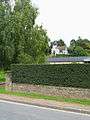 Montrelet church
See also
References
External links
| Wikimedia Commons has media related to Fieffes-Montrelet. |
- Fieffes-Montrelet, by Alain Molès and Michel Somon (French)
- Fieffes-Montrelet on the Quid website (French)
This article is issued from Wikipedia - version of the 11/8/2016. The text is available under the Creative Commons Attribution/Share Alike but additional terms may apply for the media files.