Ochancourt
| Ochancourt | |
|---|---|
|
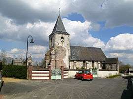
Cimetery and church. | |
 Ochancourt | |
|
Location within Hauts-de-France region  Ochancourt | |
| Coordinates: 50°06′15″N 1°36′57″E / 50.1042°N 1.6158°ECoordinates: 50°06′15″N 1°36′57″E / 50.1042°N 1.6158°E | |
| Country | France |
| Region | Hauts-de-France |
| Department | Somme |
| Arrondissement | Abbeville |
| Canton | Friville-Escarbotin |
| Intercommunality | Vimeu Industriel |
| Government | |
| • Mayor (2001–2008) | Michel Tondellier |
| Area1 | 3.95 km2 (1.53 sq mi) |
| Population (2006)2 | 259 |
| • Density | 66/km2 (170/sq mi) |
| Time zone | CET (UTC+1) |
| • Summer (DST) | CEST (UTC+2) |
| INSEE/Postal code | 80603 / 80210 |
| Elevation |
45–79 m (148–259 ft) (avg. 71 m or 233 ft) |
|
1 French Land Register data, which excludes lakes, ponds, glaciers > 1 km² (0.386 sq mi or 247 acres) and river estuaries. 2 Population without double counting: residents of multiple communes (e.g., students and military personnel) only counted once. | |
Ochancourt is a commune in the Somme department in Hauts-de-France in northern France.
Geography
Ochancourt is situated on the D48 road, some 10 miles (16 km) west of Abbeville.
Population
| 1962 | 1968 | 1975 | 1982 | 1990 | 1999 | 2006 |
|---|---|---|---|---|---|---|
| 197 | 213 | 189 | 241 | 253 | 235 | 259 |
| Starting in 1962: Population without duplicates | ||||||
History
Within the commune, on the ‘land of graves’, are said to rest the remains of those that died (9000+ ) at the Battle of Saucourt-en-Vimeu, where Louis III of France fought and defeated the Normans in 881. Other historians claim it is actually the site of the battle itself.[1]
Places of interest
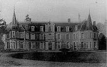
Castle, on a postcard.
- The church, with parts dating from the twelfth century.
- The family chapels in the cemetery and at the crossroads
See also
References
- ↑ Gaston Vasseur (Nibas et ses annexes).
External links
| Wikimedia Commons has media related to Ochancourt. |
- Ochancourt on the Quid website (French)
This article is issued from Wikipedia - version of the 11/8/2016. The text is available under the Creative Commons Attribution/Share Alike but additional terms may apply for the media files.