Beauval, Somme
| Beauval | ||
|---|---|---|
 | ||
| ||
 Beauval | ||
|
Location within Hauts-de-France region  Beauval | ||
| Coordinates: 50°06′23″N 2°19′49″E / 50.1064°N 2.3303°ECoordinates: 50°06′23″N 2°19′49″E / 50.1064°N 2.3303°E | ||
| Country | France | |
| Region | Hauts-de-France | |
| Department | Somme | |
| Arrondissement | Amiens | |
| Canton | Doullens | |
| Intercommunality | Communauté de communes du Doullennais | |
| Government | ||
| • Mayor (2001–2008) | Pierre Lucas | |
| Area1 | 22.56 km2 (8.71 sq mi) | |
| Population (2006)2 | 2,155 | |
| • Density | 96/km2 (250/sq mi) | |
| Time zone | CET (UTC+1) | |
| • Summer (DST) | CEST (UTC+2) | |
| INSEE/Postal code | 80071 / 80630 | |
| Elevation |
67–164 m (220–538 ft) (avg. 116 m or 381 ft) | |
|
1 French Land Register data, which excludes lakes, ponds, glaciers > 1 km² (0.386 sq mi or 247 acres) and river estuaries. 2 Population without double counting: residents of multiple communes (e.g., students and military personnel) only counted once. | ||

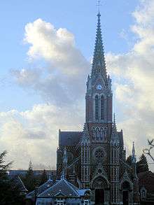
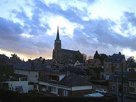
The church
Beauval is a commune in the Somme department in Hauts-de-France in northern France.
Geography
Beauval is 20 miles (32 km) north of Amiens, towards Doullens, on the national road N25.
Population
| Year | 1962 | 1968 | 1975 | 1982 | 1990 | 1999 | 2006 |
|---|---|---|---|---|---|---|---|
| Population | 2173 | 2192 | 2206 | 2274 | 2286 | 2243 | 2155 |
| From the year 1962 on: No double counting—residents of multiple communes (e.g. students and military personnel) are counted only once. | |||||||
Places and monuments
- Magnificent church; the interior has been used as the backdrop to some French films.
- The War Memorial
See also
References
External links
| Wikimedia Commons has media related to Beauval (Somme). |
(All French language)
- Beauval sur le site du Quid
- Localisation de Beauval sur une carte de France et communes limitrophes
- Plan de Beauval sur Mapquest
- Beauval sur le site de la Communauté de Communes du Doullennais
- Portail du Syndicat Mixte des Vals d'Authie, Nièvre et Somme Doullens and the surrounding area.
- Site du Syndicat Mixte des Vals d'Authie, Nièvre et Somme
This article is issued from Wikipedia - version of the 11/8/2016. The text is available under the Creative Commons Attribution/Share Alike but additional terms may apply for the media files.