Frise, Somme
| Frise | |
|---|---|
 Frise | |
|
Location within Hauts-de-France region  Frise | |
| Coordinates: 49°56′32″N 2°49′09″E / 49.9422°N 2.8192°ECoordinates: 49°56′32″N 2°49′09″E / 49.9422°N 2.8192°E | |
| Country | France |
| Region | Hauts-de-France |
| Department | Somme |
| Arrondissement | Péronne |
| Canton | Bray-sur-Somme |
| Government | |
| • Mayor (2001–2008) | Michel Richard |
| Area1 | 6.15 km2 (2.37 sq mi) |
| Population (2006)2 | 181 |
| • Density | 29/km2 (76/sq mi) |
| Time zone | CET (UTC+1) |
| • Summer (DST) | CEST (UTC+2) |
| INSEE/Postal code | 80367 / 80340 |
| Elevation |
41–99 m (135–325 ft) (avg. 50 m or 160 ft) |
|
1 French Land Register data, which excludes lakes, ponds, glaciers > 1 km² (0.386 sq mi or 247 acres) and river estuaries. 2 Population without double counting: residents of multiple communes (e.g., students and military personnel) only counted once. | |
Frise is a commune in the Somme department in Hauts-de-France in northern France.
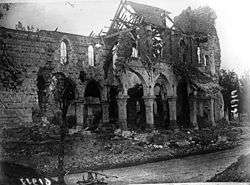
Church of Frise in 1916, after the Battle of the Somme.
Geography
Frise is situated by the banks of the river Somme, on the D471 road, some 42 kilometres (26 mi) east of Amiens.
Population
| Year | 1962 | 1968 | 1975 | 1982 | 1990 | 1999 | 2006 |
|---|---|---|---|---|---|---|---|
| Population | 137 | 145 | 112 | 131 | 129 | 158 | 181 |
| From the year 1962 on: No double counting—residents of multiple communes (e.g. students and military personnel) are counted only once. | |||||||
History
In the Middle Ages the village exploited the peat of the surrounding marshy lands. With so much fresh water, the fishing was, and still is very good in this aquatic environment.
Frise was on the front line for much of the First World War, notably the Battle of the Somme in 1916. The outline of trenches and shell holes is still visible today.
See also
References
External links
| Wikimedia Commons has media related to Frise (Somme). |
This article is issued from Wikipedia - version of the 11/8/2016. The text is available under the Creative Commons Attribution/Share Alike but additional terms may apply for the media files.