Y, Somme
| Y | ||
|---|---|---|
 | ||
| ||
 Y | ||
|
Location within Hauts-de-France region  Y | ||
| Coordinates: 49°48′14″N 2°59′34″E / 49.8039°N 2.9928°ECoordinates: 49°48′14″N 2°59′34″E / 49.8039°N 2.9928°E | ||
| Country | France | |
| Region | Hauts-de-France | |
| Department | Somme | |
| Arrondissement | Péronne | |
| Canton | Ham | |
| Government | ||
| • Mayor (2014–2020) | Vincent Joly | |
| Area1 | 2.73 km2 (1.05 sq mi) | |
| Population (2006)2 | 86 | |
| • Density | 32/km2 (82/sq mi) | |
| Time zone | CET (UTC+1) | |
| • Summer (DST) | CEST (UTC+2) | |
| INSEE/Postal code | 80829 / 80190 | |
| Elevation |
56–82 m (184–269 ft) (avg. 72 m or 236 ft) | |
|
1 French Land Register data, which excludes lakes, ponds, glaciers > 1 km² (0.386 sq mi or 247 acres) and river estuaries. 2 Population without double counting: residents of multiple communes (e.g., students and military personnel) only counted once. | ||

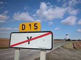
Y (pronounced: [i]) is a commune in the Somme department in Hauts-de-France in northern France.
Y bears the shortest place name in France, and one of the shortest in the world.[1] The inhabitants call themselves Ypsilonien(ne)s, from the Greek letter Upsilon which looks like the letter Y.
Geography
Y is situated 32 miles (50 km) east of Amiens, at the junction of the D15 and D615 roads, in the far eastern side of the department.
Demographics
| Year | 1962 | 1968 | 1975 | 1982 | 1990 | 1999 | 2006 |
|---|---|---|---|---|---|---|---|
| Population | 109 | 116 | 86 | 90 | 82 | 89 | 86 |
| From the year 1962 on: No double counting—residents of multiple communes (e.g. students and military personnel) are counted only once. | |||||||
See also
References
- ↑ Ash, Russell (10 November 2011). Boring, Botty and Spong. RHCP. p. 70. ISBN 978-1-4090-9739-6.
External links
| Wikimedia Commons has media related to Y, Somme. |
- Y on the Quid website (French)
This article is issued from Wikipedia - version of the 12/2/2016. The text is available under the Creative Commons Attribution/Share Alike but additional terms may apply for the media files.