Dompierre-Becquincourt
| Dompierre-Becquincourt | |
|---|---|
 Dompierre-Becquincourt | |
|
Location within Hauts-de-France region  Dompierre-Becquincourt | |
| Coordinates: 49°54′29″N 2°48′21″E / 49.9081°N 2.8058°ECoordinates: 49°54′29″N 2°48′21″E / 49.9081°N 2.8058°E | |
| Country | France |
| Region | Hauts-de-France |
| Department | Somme |
| Arrondissement | Péronne |
| Canton | Chaulnes |
| Intercommunality | Haute Picardie |
| Government | |
| • Mayor (2001–2008) | Michel Macaclin |
| Area1 | 11.05 km2 (4.27 sq mi) |
| Population (2006)2 | 654 |
| • Density | 59/km2 (150/sq mi) |
| Time zone | CET (UTC+1) |
| • Summer (DST) | CEST (UTC+2) |
| INSEE/Postal code | 80247 / 80980 |
| Elevation |
54–92 m (177–302 ft) (avg. 100 m or 330 ft) |
|
1 French Land Register data, which excludes lakes, ponds, glaciers > 1 km² (0.386 sq mi or 247 acres) and river estuaries. 2 Population without double counting: residents of multiple communes (e.g., students and military personnel) only counted once. | |
Dompierre-Becquincourt is a commune in the Somme department in Hauts-de-France in northern France.
Geography
The commune is situated on the D71 road, some 30 miles (48 km) east of Amiens.
Population
| Year | 1962 | 1968 | 1975 | 1982 | 1990 | 1999 | 2006 |
|---|---|---|---|---|---|---|---|
| Population | 693 | 703 | 635 | 646 | 664 | 642 | 654 |
| From the year 1962 on: No double counting—residents of multiple communes (e.g. students and military personnel) are counted only once. | |||||||
Gallery
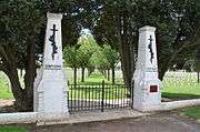 French World War I cemetery
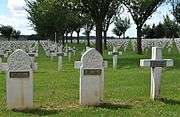 French World War I cemetery
See also
References
External links
| Wikimedia Commons has media related to Dompierre-Becquincourt. |
This article is issued from Wikipedia - version of the 11/8/2016. The text is available under the Creative Commons Attribution/Share Alike but additional terms may apply for the media files.