Montagne-Fayel
| Montagne-Fayel | |
|---|---|
 | |
 Montagne-Fayel | |
|
Location within Hauts-de-France region  Montagne-Fayel | |
| Coordinates: 49°54′54″N 1°58′55″E / 49.915°N 1.9819°E / 49.915; 1.9819Coordinates: 49°54′54″N 1°58′55″E / 49.915°N 1.9819°E / 49.915; 1.9819 | |
| Country | France |
| Region | Hauts-de-France |
| Department | Somme |
| Arrondissement | Amiens |
| Canton | Molliens-Dreuil |
| Intercommunality | Sud-Ouest Amiénois |
| Government | |
| • Mayor (2001–2008) | Jean-Marie Turlot |
| Area1 | 6.93 km2 (2.68 sq mi) |
| Population (2006)2 | 175 |
| • Density | 25/km2 (65/sq mi) |
| Time zone | CET (UTC+1) |
| • Summer (DST) | CEST (UTC+2) |
| INSEE/Postal code | 80559 / 80540 |
| Elevation |
66–132 m (217–433 ft) (avg. 133 m or 436 ft) |
|
1 French Land Register data, which excludes lakes, ponds, glaciers > 1 km² (0.386 sq mi or 247 acres) and river estuaries. 2 Population without double counting: residents of multiple communes (e.g., students and military personnel) only counted once. | |
Montagne-Fayel is a commune in the Somme department in Hauts-de-France in northern France.
Geography
The commune is situated on the D38 road, some 14 miles (23 km) west of Amiens.
Population
| 1962 | 1968 | 1975 | 1982 | 1990 | 1999 | 2006 |
|---|---|---|---|---|---|---|
| 133 | 158 | 149 | 176 | 162 | 160 | 175 |
| Starting in 1962: Population without duplicates | ||||||
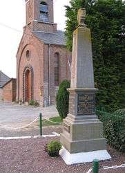
Places of interest
- The red-brick church
- The war memorial
See also
References
External links
| Wikimedia Commons has media related to Montagne-Fayel. |
- Montagne-Fayel on the Quid website (French)
This article is issued from Wikipedia - version of the 11/8/2016. The text is available under the Creative Commons Attribution/Share Alike but additional terms may apply for the media files.