Arry, Somme
| Arry | |
|---|---|
|
The castle in Arry. | |
 Arry | |
|
Location within Hauts-de-France region  Arry | |
| Coordinates: 50°16′44″N 1°43′17″E / 50.279°N 1.7214°ECoordinates: 50°16′44″N 1°43′17″E / 50.279°N 1.7214°E | |
| Country | France |
| Region | Hauts-de-France |
| Department | Somme |
| Arrondissement | Abbeville |
| Canton | Rue |
| Government | |
| • Mayor (2001–2020) | Emile Trouart |
| Area1 | 7.34 km2 (2.83 sq mi) |
| Population (2010)2 | 193 |
| • Density | 26/km2 (68/sq mi) |
| Time zone | CET (UTC+1) |
| • Summer (DST) | CEST (UTC+2) |
| INSEE/Postal code | 80030 / 80120 |
| Elevation |
2–39 m (6.6–128.0 ft) (avg. 16 m or 52 ft) |
|
1 French Land Register data, which excludes lakes, ponds, glaciers > 1 km² (0.386 sq mi or 247 acres) and river estuaries. 2 Population without double counting: residents of multiple communes (e.g., students and military personnel) only counted once. | |

Arry is a commune in the Somme department in Hauts-de-France in northern France.
Geography
The commune is situated about 1 kilometre from the A16 autoroute, on the D938 road to Rue.
Population
| Year | 1962 | 1968 | 1975 | 1982 | 1990 | 1999 | 2006 |
|---|---|---|---|---|---|---|---|
| Population | 155 | 182 | 191 | 176 | 158 | 164 | 165 |
| From the year 1962 on: No double counting—residents of multiple communes (e.g. students and military personnel) are counted only once. | |||||||
See also
Communes of the Somme department
Monument aux morts
The monument aux morts in this commune features a sculpture by Louis-Henri Leclabart. A montage of photographs of this monument aux morts, which stands in front of the church, is shown below.
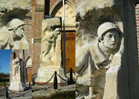
The Arry monument aux morts.
References
External links
| Wikimedia Commons has media related to Arry (Somme). |
(All French)
- Arry on the website of Quid
- Position of Arry on a map of France
- Map of Arry on Mapquest
- The monument aux morts of the Western Somme Article on monument aux morts
This article is issued from Wikipedia - version of the 11/8/2016. The text is available under the Creative Commons Attribution/Share Alike but additional terms may apply for the media files.