Azy-sur-Marne
| Azy-sur-Marne | |
|---|---|
|
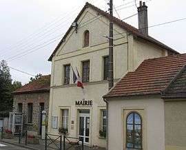
The Town Hall | |
 Azy-sur-Marne | |
|
Location within Hauts-de-France region  Azy-sur-Marne | |
| Coordinates: 49°00′07″N 3°22′01″E / 49.0019°N 3.3669°ECoordinates: 49°00′07″N 3°22′01″E / 49.0019°N 3.3669°E | |
| Country | France |
| Region | Hauts-de-France |
| Department | Aisne |
| Arrondissement | Château-Thierry |
| Canton | Château-Thierry |
| Intercommunality | Région de Château Thierry |
| Government | |
| • Mayor (2014–2020) | Jean-Pierre Lantoine |
| Area1 | 2.78 km2 (1.07 sq mi) |
| Population (2010)2 | 387 |
| • Density | 140/km2 (360/sq mi) |
| Time zone | CET (UTC+1) |
| • Summer (DST) | CEST (UTC+2) |
| INSEE/Postal code | 02042 / 02400 |
| Elevation |
57–202 m (187–663 ft) (avg. 60 m or 200 ft) |
|
1 French Land Register data, which excludes lakes, ponds, glaciers > 1 km² (0.386 sq mi or 247 acres) and river estuaries. 2 Population without double counting: residents of multiple communes (e.g., students and military personnel) only counted once. | |
Azy-sur-Marne is a French commune in the department of Aisne in the Hauts-de-France region of northern France.
The inhabitants of the commune are known as Azyciens or Azyciennes[1]
Geography
Azy-sur-Marne is located 4 km south-west of Château-Thierry and 20 km east of Montreuil-aux-Lions. It can be accessed by the D969 road from Essômes-sur-Marne in the north through the village then west through the commune and continuing south to Romeny-sur-Marne. There is also a country road going west to Mont de Bonneil. The commune is almost entirely farmland with small forests in the north and west. The commune is within the Appellation d'origine contrôlée zone of Aisne Champagne.[2]
The southern border of the commune consists of the Marne river with no other identifiable watercourses in the commune.[2]
Neighbouring communes and villages[2]
 |
Crogis | Essômes-sur-Marne | Nogentel | |
| Bonneil | |
|||
| ||||
| | ||||
| Romeny-sur-Marne | Chézy-sur-Marne |
History
The village was severely damaged in the battles of the Marne in World War I.
Administration
List of Successive Mayors of Azy-sur-Marne[3]
| From | To | Name | Party | Position |
|---|---|---|---|---|
| 2001 | 2014 | Peter Pastorelli | DVG | |
| 2014 | 2020 | Jean-Pierre Lantoine |
(Not all data is known)
Demography
In 2010 the commune had 387 inhabitants. The evolution of the number of inhabitants is known through the population censuses conducted in the commune since 1793. From the 21st century, a census of municipalities with fewer than 10,000 inhabitants is held every five years, unlike larger towns that have a sample survey every year.[Note 1]
| 1793 | 1800 | 1806 | 1821 | 1831 | 1836 | 1841 | 1846 | 1851 |
|---|---|---|---|---|---|---|---|---|
| 253 | 266 | 276 | 246 | 259 | 265 | 254 | 245 | 251 |
| 1856 | 1861 | 1866 | 1872 | 1876 | 1881 | 1886 | 1891 | 1896 |
|---|---|---|---|---|---|---|---|---|
| 223 | 315 | 252 | 192 | 191 | 193 | 187 | 199 | 189 |
| 1901 | 1906 | 1911 | 1921 | 1926 | 1931 | 1936 | 1946 | 1954 |
|---|---|---|---|---|---|---|---|---|
| 194 | 176 | 168 | 160 | 181 | 195 | 167 | 167 | 173 |
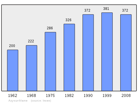
| 1962 | 1968 | 1975 | 1982 | 1990 | 1999 | 2006 | 2010 | - |
|---|---|---|---|---|---|---|---|---|
| 200 | 222 | 286 | 326 | 372 | 381 | 372 | 387 | - |
Sources : Ldh/EHESS/Cassini until 1962, INSEE database from 1968 (population without double counting and municipal population from 2006)
Sites and Monuments
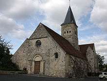
The commune has two sites that are registered as historical monuments:
- Other sites of interest
- the Mercier Vineyard for Moët & Chandon Champagne
See also
External links
- Azy-sur-Marne on the old National Geographic Institute website (French)
- Bell Towers website (French)
- Azy-sur-Marne on Lion1906
- Azy-sur-Marne on Google Maps
- Azy-sur-Marne on Géoportail, National Geographic Institute (IGN) website (French)
- Azy on the 1750 Cassini Map
- Azy-sur-Marne on the INSEE website (French)
- INSEE (French)
Notes and references
Notes
- ↑ At the beginning of the 21st century, the methods of identification have been modified by law No. 2002-276 of 27 February 2002 , the so-called "law of local democracy" and in particular Title V "census operations" which allow, after a transitional period running from 2004 to 2008, the annual publication of the legal population of the different French administrative districts. For municipalities with a population greater than 10,000 inhabitants, a sample survey is conducted annually, the entire territory of these municipalities is taken into account at the end of the period of five years. The first "legal population" after 1999 under this new law came into force on 1 January 2009 and was based on the census of 2006.
References
- ↑ Inhabitants of Aisne (French)
- 1 2 3 Google Maps
- ↑ List of Mayors of France (French)
- ↑ Ministry of Culture, Mérimée PA00115515 Church of Saint Felix (French)

- ↑ Ministry of Culture, Mérimée IA02001298 Chateau Park (French)
| Wikimedia Commons has media related to Azy-sur-Marne. |