Remies
| Remies | |
|---|---|
|
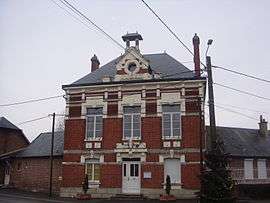
Town hall | |
 Remies | |
|
Location within Hauts-de-France region  Remies | |
| Coordinates: 49°40′47″N 3°31′16″E / 49.6797°N 3.5211°ECoordinates: 49°40′47″N 3°31′16″E / 49.6797°N 3.5211°E | |
| Country | France |
| Region | Hauts-de-France |
| Department | Aisne |
| Arrondissement | Laon |
| Canton | Crécy-sur-Serre |
| Intercommunality | Pays de la Serre |
| Government | |
| • Mayor (2008–2014) | Bernard Collet |
| Area1 | 8.98 km2 (3.47 sq mi) |
| Population (2008)2 | 239 |
| • Density | 27/km2 (69/sq mi) |
| Time zone | CET (UTC+1) |
| • Summer (DST) | CEST (UTC+2) |
| INSEE/Postal code | 02638 / 02270 |
| Elevation |
52–88 m (171–289 ft) (avg. 56 m or 184 ft) |
|
1 French Land Register data, which excludes lakes, ponds, glaciers > 1 km² (0.386 sq mi or 247 acres) and river estuaries. 2 Population without double counting: residents of multiple communes (e.g., students and military personnel) only counted once. | |
Remies is a commune in the Aisne department in Hauts-de-France in northern France.
Population
| Historical population | ||
|---|---|---|
| Year | Pop. | ±% |
| 1793 | 384 | — |
| 1800 | 483 | +25.8% |
| 1806 | 498 | +3.1% |
| 1821 | 484 | −2.8% |
| 1831 | 584 | +20.7% |
| 1836 | 567 | −2.9% |
| 1841 | 557 | −1.8% |
| 1846 | 567 | +1.8% |
| 1851 | 572 | +0.9% |
| 1856 | 554 | −3.1% |
| 1861 | 514 | −7.2% |
| 1866 | 505 | −1.8% |
| 1872 | 490 | −3.0% |
| 1876 | 464 | −5.3% |
| 1881 | 485 | +4.5% |
| 1886 | 507 | +4.5% |
| 1891 | 470 | −7.3% |
| 1896 | 440 | −6.4% |
| 1901 | 429 | −2.5% |
| 1906 | 404 | −5.8% |
| 1911 | 353 | −12.6% |
| 1921 | 330 | −6.5% |
| 1926 | 316 | −4.2% |
| 1931 | 286 | −9.5% |
| 1936 | 311 | +8.7% |
| 1946 | 299 | −3.9% |
| 1954 | 329 | +10.0% |
| 1962 | 289 | −12.2% |
| 1968 | 272 | −5.9% |
| 1975 | 245 | −9.9% |
| 1982 | 243 | −0.8% |
| 1990 | 220 | −9.5% |
| 1999 | 230 | +4.5% |
| 2008 | 239 | +3.9% |
See also
References
| Wikimedia Commons has media related to Remies. |
This article is issued from Wikipedia - version of the 11/8/2016. The text is available under the Creative Commons Attribution/Share Alike but additional terms may apply for the media files.