Bony, Aisne
| Bony | |
|---|---|
 Bony | |
|
Location within Hauts-de-France region  Bony | |
| Coordinates: 49°59′20″N 3°13′25″E / 49.9889°N 3.2236°ECoordinates: 49°59′20″N 3°13′25″E / 49.9889°N 3.2236°E | |
| Country | France |
| Region | Hauts-de-France |
| Department | Aisne |
| Arrondissement | Saint-Quentin |
| Canton | Le Catelet |
| Intercommunality | Pays du Vermandois |
| Government | |
| • Mayor (2008–2014) | Philippe Gyselinck |
| Area1 | 7.98 km2 (3.08 sq mi) |
| Population (2008)2 | 128 |
| • Density | 16/km2 (42/sq mi) |
| Time zone | CET (UTC+1) |
| • Summer (DST) | CEST (UTC+2) |
| INSEE/Postal code | 02100 / 02420 |
| Elevation |
87–146 m (285–479 ft) (avg. 115 m or 377 ft) |
|
1 French Land Register data, which excludes lakes, ponds, glaciers > 1 km² (0.386 sq mi or 247 acres) and river estuaries. 2 Population without double counting: residents of multiple communes (e.g., students and military personnel) only counted once. | |
Bony is a commune in the department of Aisne in Hauts-de-France in northern France.
Population
| Historical population | ||
|---|---|---|
| Year | Pop. | ±% |
| 1962 | 152 | — |
| 1968 | 110 | −27.6% |
| 1975 | 109 | −0.9% |
| 1982 | 125 | +14.7% |
| 1990 | 101 | −19.2% |
| 1999 | 124 | +22.8% |
| 2008 | 128 | +3.2% |
Gallery
-
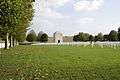
Military cemetery of the United States in Bony
See also
References
| Wikimedia Commons has media related to Bony, Aisne. |
This article is issued from Wikipedia - version of the 11/8/2016. The text is available under the Creative Commons Attribution/Share Alike but additional terms may apply for the media files.