Achery, Aisne
| Achery | |
|---|---|
|
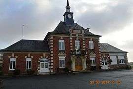
Achery Town Hall | |
 Achery | |
|
Location within Hauts-de-France region  Achery | |
| Coordinates: 49°41′35″N 3°23′26″E / 49.6931°N 3.3906°ECoordinates: 49°41′35″N 3°23′26″E / 49.6931°N 3.3906°E | |
| Country | France |
| Region | Hauts-de-France |
| Department | Aisne |
| Arrondissement | Laon |
| Canton | La Fère |
| Intercommunality | Villes d'Oyse |
| Government | |
| • Mayor (2008–2020) | Georges Demoulin |
| Area1 | 6.9 km2 (2.7 sq mi) |
| Population (2012)2 | 620 |
| • Density | 90/km2 (230/sq mi) |
| Time zone | CET (UTC+1) |
| • Summer (DST) | CEST (UTC+2) |
| INSEE/Postal code | 02002 / 02800 |
| Elevation |
48–103 m (157–338 ft) (avg. 50 m or 160 ft) |
|
1 French Land Register data, which excludes lakes, ponds, glaciers > 1 km² (0.386 sq mi or 247 acres) and river estuaries. 2 Population without double counting: residents of multiple communes (e.g., students and military personnel) only counted once. | |
Achery is a French commune in the department of Aisne in the Hauts-de-France region of northern France.
The inhabitants of the commune are known as Acheryens or Acheryennes.[1]
Geography
Achery is located some 20 km south by south-east of Saint-Quentin and 10 km north-east of Tergnier. The commune is on the Oise river which flows south forming the north-western border of the commune before flowing through the commune and continuing south. The tributary of the Oise, the Serre, forms the southern border of the commune before joining the Oise just south of Achery. The town of Achery is about 1.5 km directly south of Mayot on Highway D13 which passes through Achery south to Danizy. Other roads into the commune are the D643 (Rue Jules Lesage) west from the village to Travecy and also east (Rue Jean Moulin) to Anguilcourt-le-Sart. The Rue de Fort forms most of the northern border of the commune with various country roads forming most of the western border.[2]
Neighbouring communes and villages[2]
 |
Vendeuil | Mayot | Villers-le-Sec | |
| Travecy | |
Anguilcourt-le-Sart | ||
| ||||
| | ||||
| Beautor | Danizy | Monceau-les-Leups |
Some distance from the town there is a quarry and an old gunpowder factory.
History
In the distant past, the village was called Achiriacus in 990.
Achery had its own lords. The lordship had his castle but it was destroyed once before being rebuilt in the 14th century. The lordship fell to the Count of Anizy. During the French Revolution the castle was destroyed and Achery became an independent commune. During the First World War, the village was completely destroyed but was rebuilt after the war.
Administration
List of Mayors of Achery[3]
| From | To | Name | Party | Position |
|---|---|---|---|---|
| 2001 | 2020 | Georges Demoulin | DVD |
(Not all data is known)
Demography
In 2012, the commune had 620 inhabitants. The evolution of the number of inhabitants is known through the population censuses conducted in the town since 1793. From the 21st century, a census of municipalities with fewer than 10,000 inhabitants is held every five years, unlike larger towns that have a sample survey every year.[Note 1] [Note 2]
| 1793 | 1800 | 1806 | 1821 | 1831 | 1836 | 1841 | 1846 | 1851 |
|---|---|---|---|---|---|---|---|---|
| 689 | 761 | 754 | 862 | 1,046 | 1,099 | 1,125 | 1,117 | 1,088 |
| 1856 | 1861 | 1866 | 1872 | 1876 | 1881 | 1886 | 1891 | 1896 |
|---|---|---|---|---|---|---|---|---|
| 1,099 | 1,074 | 1,046 | 924 | 927 | 895 | 908 | 809 | 763 |
| 1901 | 1906 | 1911 | 1921 | 1926 | 1931 | 1936 | 1946 | 1954 |
|---|---|---|---|---|---|---|---|---|
| 671 | 687 | 655 | 451 | 464 | 449 | 469 | 520 | 501 |
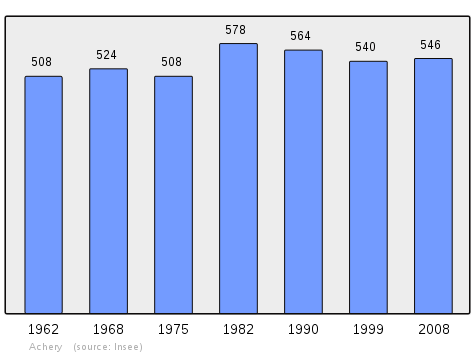
| 1962 | 1968 | 1975 | 1982 | 1990 | 1999 | 2006 | 2010 | - |
|---|---|---|---|---|---|---|---|---|
| 508 | 524 | 508 | 578 | 564 | 540 | 533 | 587 | - |
Sources : Ldh/EHESS/Cassini until 1962, INSEE database from 1968 (population without double counting and municipal population from 2006)
Events
- Flea market in May
- Festival on the third Sunday in June
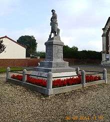
Sites and monuments
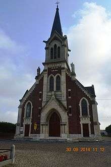

- The Church of Saint-Martin: rebuilt after the First World War
- An Old water mill
- The Dovecote Square
- Marshes and ponds
- Remains of many blockhouses of the Hindenburg Line
See also
External links
- Achery on Lion1906
- Achery on Google Maps
- Achery on Géoportail, National Geographic Institute (IGN) website (French)
- Achery on the 1750 Cassini Map
- Achery on the INSEE website (French)
- INSEE (French)
Notes and references
Notes
- ↑ At the beginning of the 21st century, the methods of identification have been modified by law No. 2002-276 of 27 February 2002 , the so-called "law of local democracy" and in particular Title V "census operations" which allow, after a transitional period running from 2004 to 2008, the annual publication of the legal population of the different French administrative districts. For municipalities with a population greater than 10,000 inhabitants, a sample survey is conducted annually, the entire territory of these municipalities is taken into account at the end of the period of five years. The first "legal population" after 1999 under this new law came into force on 1 January 2009 and was based on the census of 2006.
- ↑ In the census table and the graph, by convention in Wikipedia, and to allow a fair comparison between five yearly censuses, the principle has been retained for subsequent legal populations since 1999 displayed in the census table and the graph that shows populations for the years 2006, 2011, 2016, etc.. , as well as the latest legal population published by INSEE
References
| Wikimedia Commons has media related to Achery. |