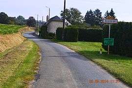
Bagneux, Aisne
| Bagneux | |
|---|---|
 | |
 Bagneux | |
|
Location within Hauts-de-France region  Bagneux | |
| Coordinates: 49°27′29″N 3°16′46″E / 49.4581°N 3.2794°ECoordinates: 49°27′29″N 3°16′46″E / 49.4581°N 3.2794°E | |
| Country | France |
| Region | Hauts-de-France |
| Department | Aisne |
| Arrondissement | Soissons |
| Canton | Vic-sur-Aisne |
| Intercommunality | Soissonnais |
| Government | |
| • Mayor (2001–2020) | Jean-Marie Dubois |
| Area1 | 2.21 km2 (0.85 sq mi) |
| Population (2010)2 | 73 |
| • Density | 33/km2 (86/sq mi) |
| Time zone | CET (UTC+1) |
| • Summer (DST) | CEST (UTC+2) |
| INSEE/Postal code | 02043 / 02290 |
| Elevation |
72–149 m (236–489 ft) (avg. 88 m or 289 ft) |
|
1 French Land Register data, which excludes lakes, ponds, glaciers > 1 km² (0.386 sq mi or 247 acres) and river estuaries. 2 Population without double counting: residents of multiple communes (e.g., students and military personnel) only counted once. | |
Bagneux is a French commune in the department of Aisne in the Hauts-de-France region of northern France.
Geography
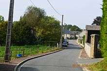
Bagneux is located some 10 km north by north-west of Soissons and 25 km south-east of Noyon. It can be accessed by road D428 from Épagny in the west running east through the commune to Juvigny. The south and west of the commune are heavily forested slopes with the rest of the commune flat farmland.[1]
Part of the southern border of the commune is formed by Le Plat Ru stream which joins the Ru de Mareuil which is the western border of the commune and continues westwards.[1]
Neighbouring communes and villages[1]
 |
Trosly-Loire | Pont-Saint-Mard | Crécy-au-Mont | |
| Épagny | |
Leuilly-sous-Coucy | ||
| ||||
| | ||||
| Tartiers | Vauxrezis | Juvigny |
History
In the second round of the French presidential election of 2002 Bagneux had the fifteenth largest vote for Jean-Marie Le Pen in France. His score in the commune was 53.85% of the total vote.[2]
Administration
List of Successive Mayors of Bagneux[3]
| From | To | Name |
|---|---|---|
| 1790 | 1790 | Louis François Garnier |
| 1790 | 1793 | Jean Baptiste Alliette |
| 1793 | 1793 | Pierre Moreau |
| 1793 | 1794 | Jean Denis Leve |
| 1794 | 1794 | Charles Louis Varnier |
| 1794 | 1794 | François Augustin Garnier |
| 1794 | 1794 | Charles François Charpentier |
| 1794 | 1794 | Jean François Lardo |
| 1794 | 1794 | Pierre Bouchard |
| 1794 | 1794 | Denis Bancelin |
| 1794 | 1794 | Jean Baptiste Lardo |
| 1794 | 1794 | Nicolas Cordier |
| 1794 | 1795 | Pierre Robert Plateaux |
| 1795 | 1801 | Jean Baptiste Fortin |
| 1801 | 1807 | Pierre Christophe Vollee |
| 1809 | 1810 | Varnier |
| 1811 | 1812 | Lerat |
| 1812 | 1815 | Jean André Bancelin |
| 1815 | 1825 | Auguste Pierre de Varenne |
| 1826 | 1834 | Louis Michel Garnier |
| 1834 | 1836 | François Edmé Joseph Martineau |
| 1836 | 1840 | Charles Philippe Bazin |
| 1840 | 1848 | François Bauzon |
| 1848 | 1854 | Denis André Bancelin |
| 1854 | 1858 | Louis Pierre Prosper Bancelin |
| 1858 | 1865 | Louis Pierre Rousseau |
| 1865 | 1869 | François Louis Charles Huillier |
| 1869 | 1870 | Louis Surivet |
| 1870 | 1881 | Philippe Auguste Leviaux |
| 1881 | 1888 | Achille Gruyer |
| 1888 | 1899 | Jean Baptiste Dervieux |
| 1899 | 1935 | Théodore Richard Tissier |
| 1935 | 1939 | Albert Petit |
| 1939 | 1941 | FlorenceN |
- Mayors from 1941
| From | To | Name | Party | Position |
|---|---|---|---|---|
| 1941 | 1944 | Maurice Grandjean | ||
| 1944 | 1945 | Piret | ||
| 1945 | 1963 | Albert Petit | ||
| 1963 | 1985 | Henri Ravera | ||
| 1985 | 2001 | Janine Jambu | ||
| 2001 | 2020 | Jean-Marie Dubois | DVG |
(Not all data is known)
Demography
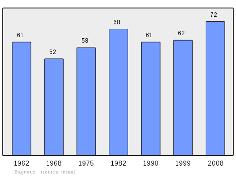
In 2010, the commune had 73 inhabitants. The evolution of the number of inhabitants is known through the population censuses conducted in the commune since 1793. From the 21st century, a census of municipalities with fewer than 10,000 inhabitants is held every five years, unlike larger towns that have a sample survey every year.[Note 1]
| 1793 | 1800 | 1806 | 1821 | 1831 | 1836 | 1841 | 1846 | 1851 |
|---|---|---|---|---|---|---|---|---|
| 80 | 94 | 91 | 93 | 120 | 77 | 112 | 108 | 114 |
| 1856 | 1861 | 1866 | 1872 | 1876 | 1881 | 1886 | 1891 | 1896 |
|---|---|---|---|---|---|---|---|---|
| 118 | 121 | 118 | 129 | 138 | 122 | 123 | 123 | 104 |
| 1901 | 1906 | 1911 | 1921 | 1926 | 1931 | 1936 | 1946 | 1954 |
|---|---|---|---|---|---|---|---|---|
| 94 | 124 | 113 | 67 | 81 | 79 | 77 | 75 | 67 |
| 1962 | 1968 | 1975 | 1982 | 1990 | 1999 | 2006 | 2009 | 2010 |
|---|---|---|---|---|---|---|---|---|
| 61 | 52 | 58 | 68 | 61 | 62 | 71 | 72 | 73 |
Sources : Ldh/EHESS/Cassini until 1962, INSEE database from 1968 (population without double counting and municipal population from 2006)
Sites and monuments

The Church contains two items that are registered as historical objects:
- A Group Sculpture: Saint Martin and the pauper (16th century)
 [4]
[4] - A Baptismal font (destroyed) (13th century)[5]
See also
External links
- Bagneux on the old IGN website (French)
- 40000 Bell Towers website (French)
- Agglomeration Community of Soissonnais website (French)
- Bagneux on Lion1906
- Bagneux on Google Maps
- Bagneux on Géoportail, National Geographic Institute (IGN) website (French)
- Bagneux on the 1750 Cassini Map
- Bagneux on the INSEE website (French)
- INSEE (French)
Notes and references
Notes
- ↑ At the beginning of the 21st century, the methods of identification have been modified by law No. 2002-276 of 27 February 2002 , the so-called "law of local democracy" and in particular Title V "census operations" which allow, after a transitional period running from 2004 to 2008, the annual publication of the legal population of the different French administrative districts. For municipalities with a population greater than 10,000 inhabitants, a sample survey is conducted annually, the entire territory of these municipalities is taken into account at the end of the period of five years. The first "legal population" after 1999 under this new law came into force on 1 January 2009 and was based on the census of 2006.
References
- 1 2 3 Google Maps
- ↑ Presidential Election 2002 results
- ↑ List of Mayors of France (French)
- ↑ Ministry of Culture, Palissy PM02000064 Group Sculpture: Saint Martin and the pauper (French)
- ↑ Ministry of Culture, Palissy PM02000063 Baptismal font (French)
| Wikimedia Commons has media related to Bagneux (Aisne). |