Saint-Michel, Aisne
| Saint-Michel | ||
|---|---|---|
|
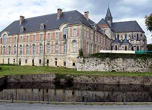
Saint-Michel Abbey | ||
| ||
 Saint-Michel | ||
|
Location within Hauts-de-France region  Saint-Michel | ||
| Coordinates: 49°55′07″N 4°08′01″E / 49.9186°N 4.1336°ECoordinates: 49°55′07″N 4°08′01″E / 49.9186°N 4.1336°E | ||
| Country | France | |
| Region | Hauts-de-France | |
| Department | Aisne | |
| Arrondissement | Vervins | |
| Canton | Hirson | |
| Intercommunality | Pays des Trois Rivières | |
| Government | ||
| • Mayor (2008–2014) | Thierry Verdavaine | |
| Area1 | 42.2 km2 (16.3 sq mi) | |
| Population (2012)2 | 3,542 | |
| • Density | 84/km2 (220/sq mi) | |
| Time zone | CET (UTC+1) | |
| • Summer (DST) | CEST (UTC+2) | |
| INSEE/Postal code | 02684 / 02830 | |
| Elevation |
172–278 m (564–912 ft) (avg. 201 m or 659 ft) | |
|
1 French Land Register data, which excludes lakes, ponds, glaciers > 1 km² (0.386 sq mi or 247 acres) and river estuaries. 2 Population without double counting: residents of multiple communes (e.g., students and military personnel) only counted once. | ||
.svg.png)
Saint-Michel is a commune in the Aisne department in Hauts-de-France in northern France. It is also unofficially called Saint-Michel-en-Thiérache.
Population
| Historical population | ||
|---|---|---|
| Year | Pop. | ±% |
| 1962 | 4,502 | — |
| 1968 | 4,342 | −3.6% |
| 1975 | 4,155 | −4.3% |
| 1982 | 4,044 | −2.7% |
| 1990 | 3,783 | −6.5% |
| 1999 | 3,656 | −3.4% |
| 2008 | 3,522 | −3.7% |
| 2012 | 3,542 | +0.6% |
Personalities
- French Revolution leader Antoine Joseph Santerre, whose family moved from Saint-Michel to Paris before the Revolution.
See also
References
| Wikimedia Commons has media related to Saint-Michel, Aisne. |
This article is issued from Wikipedia - version of the 11/8/2016. The text is available under the Creative Commons Attribution/Share Alike but additional terms may apply for the media files.