Binas
For the Dutch science book, see BINAS.
| Binas | ||
|---|---|---|
|
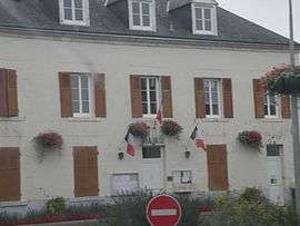
Town hall | ||
| ||
 Binas | ||
|
Location within Centre-Val de Loire region  Binas | ||
| Coordinates: 47°54′15″N 1°27′48″E / 47.9042°N 1.4633°ECoordinates: 47°54′15″N 1°27′48″E / 47.9042°N 1.4633°E | ||
| Country | France | |
| Region | Centre-Val de Loire | |
| Department | Loir-et-Cher | |
| Arrondissement | Blois | |
| Canton | Ouzouer-le-Marché | |
| Intercommunality | Beauce oratorienne | |
| Government | ||
| • Mayor (2014–2020) | Solange Vallée | |
| Area1 | 26.38 km2 (10.19 sq mi) | |
| Population (2013)2 | 717 | |
| • Density | 27/km2 (70/sq mi) | |
| Time zone | CET (UTC+1) | |
| • Summer (DST) | CEST (UTC+2) | |
| INSEE/Postal code | 41017 / 41240 | |
| Elevation |
120–133 m (394–436 ft) (avg. 128 m or 420 ft) | |
|
1 French Land Register data, which excludes lakes, ponds, glaciers > 1 km² (0.386 sq mi or 247 acres) and river estuaries. 2 Population without double counting: residents of multiple communes (e.g., students and military personnel) only counted once. | ||
.svg.png)
Binas is a commune in the Loir-et-Cher department in central France.
Population
| Historical population | ||
|---|---|---|
| Year | Pop. | ±% |
| 1793 | 1,040 | — |
| 1800 | 952 | −8.5% |
| 1806 | 900 | −5.5% |
| 1821 | 917 | +1.9% |
| 1831 | 1,100 | +20.0% |
| 1836 | 1,029 | −6.5% |
| 1841 | 1,159 | +12.6% |
| 1846 | 1,279 | +10.4% |
| 1851 | 1,221 | −4.5% |
| 1856 | 1,307 | +7.0% |
| 1861 | 1,233 | −5.7% |
| 1866 | 1,297 | +5.2% |
| 1872 | 1,300 | +0.2% |
| 1876 | 1,235 | −5.0% |
| 1881 | 1,226 | −0.7% |
| 1886 | 1,167 | −4.8% |
| 1891 | 1,141 | −2.2% |
| 1896 | 1,074 | −5.9% |
| 1901 | 1,085 | +1.0% |
| 1906 | 1,101 | +1.5% |
| 1911 | 1,071 | −2.7% |
| 1921 | 963 | −10.1% |
| 1926 | 962 | −0.1% |
| 1931 | 966 | +0.4% |
| 1936 | 900 | −6.8% |
| 1946 | 902 | +0.2% |
| 1954 | 871 | −3.4% |
| 1962 | 866 | −0.6% |
| 1968 | 813 | −6.1% |
| 1975 | 746 | −8.2% |
| 1982 | 689 | −7.6% |
| 1990 | 601 | −12.8% |
| 1999 | 593 | −1.3% |
| 2006 | 689 | +16.2% |
| 2009 | 725 | +5.2% |
See also
References
| Wikimedia Commons has media related to Binas. |
This article is issued from Wikipedia - version of the 11/10/2016. The text is available under the Creative Commons Attribution/Share Alike but additional terms may apply for the media files.