Lavardin, Loir-et-Cher
| Lavardin | ||
|---|---|---|
|
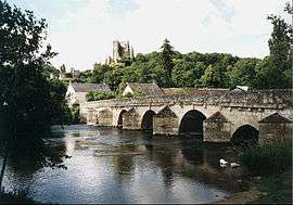
The 14th-century bridge and 15th-18th-century château | ||
| ||
 Lavardin | ||
|
Location within Centre-Val de Loire region  Lavardin | ||
| Coordinates: 47°44′33″N 0°53′13″E / 47.7425°N 0.8869°ECoordinates: 47°44′33″N 0°53′13″E / 47.7425°N 0.8869°E | ||
| Country | France | |
| Region | Centre-Val de Loire | |
| Department | Loir-et-Cher | |
| Arrondissement | Vendôme | |
| Canton | Montoire-sur-le-Loir | |
| Area1 | 6.71 km2 (2.59 sq mi) | |
| Population (1999)2 | 262 | |
| • Density | 39/km2 (100/sq mi) | |
| Time zone | CET (UTC+1) | |
| • Summer (DST) | CEST (UTC+2) | |
| INSEE/Postal code | 41113 / 41800 | |
| Elevation |
63–146 m (207–479 ft) (avg. 71 m or 233 ft) | |
|
1 French Land Register data, which excludes lakes, ponds, glaciers > 1 km² (0.386 sq mi or 247 acres) and river estuaries. 2 Population without double counting: residents of multiple communes (e.g., students and military personnel) only counted once. | ||
.svg.png)
Lavardin is a commune in the Loir-et-Cher department of central France.
It is located on the banks of the Loir River.
Its inhabitants are called Lavardinoises and Lavardinois.
The village is a member of the association of Les Plus Beaux Villages de France ("The most beautiful villages of France").
Sites and monuments
Lavardin is classified as one of the most beautiful villages of France thanks to the ruins of its mediaeval castle (see main article: Château de Lavardin), its Gothic church and frescoes, its houses and the ancient bridge. The village has been frequented by renowned painters since about 1900, most notably Busson and Sauvage.
References
External links
- Official village website for Lavardin (English)
- Association des plus beaux villages de France: Lavardin (English)
- Lavardin on the Institut géographique national site (French)
| Wikimedia Commons has media related to Lavardin, Loir-et-Cher. |
This article is issued from Wikipedia - version of the 3/1/2015. The text is available under the Creative Commons Attribution/Share Alike but additional terms may apply for the media files.