Arville, Loir-et-Cher
| Arville | ||
|---|---|---|
|
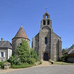
Church of Our Lady | ||
| ||
 Arville | ||
|
Location within Centre-Val de Loire region  Arville | ||
| Coordinates: 48°03′49″N 0°56′53″E / 48.0636°N 0.9481°ECoordinates: 48°03′49″N 0°56′53″E / 48.0636°N 0.9481°E | ||
| Country | France | |
| Region | Centre-Val de Loire | |
| Department | Loir-et-Cher | |
| Arrondissement | Vendôme | |
| Canton | Mondoubleau | |
| Intercommunality | Collines du Perche | |
| Government | ||
| • Mayor (2014–2020) | Henri Lemerre | |
| Area1 | 9.75 km2 (3.76 sq mi) | |
| Population (2013)2 | 73 | |
| • Density | 7.5/km2 (19/sq mi) | |
| Time zone | CET (UTC+1) | |
| • Summer (DST) | CEST (UTC+2) | |
| INSEE/Postal code | 41005 / 41170 | |
| Elevation | 157–204 m (515–669 ft) | |
|
1 French Land Register data, which excludes lakes, ponds, glaciers > 1 km² (0.386 sq mi or 247 acres) and river estuaries. 2 Population without double counting: residents of multiple communes (e.g., students and military personnel) only counted once. | ||

Arville is a commune in the Loir-et-Cher department in central France.
Sights
Arville's 12th-Century commandry now hosts a museum on the Crusades and the Knights Templar.
Population
| Historical population | ||
|---|---|---|
| Year | Pop. | ±% |
| 1793 | 350 | — |
| 1800 | 346 | −1.1% |
| 1806 | 385 | +11.3% |
| 1821 | 409 | +6.2% |
| 1831 | 399 | −2.4% |
| 1836 | 430 | +7.8% |
| 1841 | 388 | −9.8% |
| 1846 | 385 | −0.8% |
| 1851 | 358 | −7.0% |
| 1856 | 371 | +3.6% |
| 1861 | 347 | −6.5% |
| 1866 | 349 | +0.6% |
| 1872 | 318 | −8.9% |
| 1876 | 344 | +8.2% |
| 1881 | 329 | −4.4% |
| 1886 | 358 | +8.8% |
| 1891 | 376 | +5.0% |
| 1896 | 374 | −0.5% |
| 1901 | 355 | −5.1% |
| 1906 | 334 | −5.9% |
| 1911 | 314 | −6.0% |
| 1921 | 303 | −3.5% |
| 1926 | 307 | +1.3% |
| 1931 | 288 | −6.2% |
| 1936 | 288 | +0.0% |
| 1946 | 274 | −4.9% |
| 1954 | 248 | −9.5% |
| 1962 | 229 | −7.7% |
| 1968 | 228 | −0.4% |
| 1975 | 178 | −21.9% |
| 1982 | 152 | −14.6% |
| 1990 | 122 | −19.7% |
| 1999 | 108 | −11.5% |
| 2006 | 118 | +9.3% |
| 2009 | 119 | +0.8% |
See also
References
External links
- The Commandry Official site
- French Ministry of Culture site for Arville (French)
- Map of Arville on Michelin (English)
| Wikimedia Commons has media related to Arville (Loir-et-Cher). |
This article is issued from Wikipedia - version of the 11/10/2016. The text is available under the Creative Commons Attribution/Share Alike but additional terms may apply for the media files.