Menars
| Menars | ||
|---|---|---|
|
| ||
| ||
 Menars | ||
|
Location within Centre-Val de Loire region  Menars | ||
| Coordinates: 47°38′36″N 1°24′34″E / 47.6433°N 1.4094°ECoordinates: 47°38′36″N 1°24′34″E / 47.6433°N 1.4094°E | ||
| Country | France | |
| Region | Centre-Val de Loire | |
| Department | Loir-et-Cher | |
| Arrondissement | Blois | |
| Canton | Mer | |
| Intercommunality | Communauté d'agglomération de Blois | |
| Government | ||
| • Mayor | Yves Georges | |
| Area1 | 4.5 km2 (1.7 sq mi) | |
| Population (1999)2 | 574 | |
| • Density | 130/km2 (330/sq mi) | |
| Time zone | CET (UTC+1) | |
| • Summer (DST) | CEST (UTC+2) | |
| INSEE/Postal code | 41134 / 41500 | |
| Elevation |
67–111 m (220–364 ft) (avg. 98 m or 322 ft) | |
|
1 French Land Register data, which excludes lakes, ponds, glaciers > 1 km² (0.386 sq mi or 247 acres) and river estuaries. 2 Population without double counting: residents of multiple communes (e.g., students and military personnel) only counted once. | ||
.svg.png)
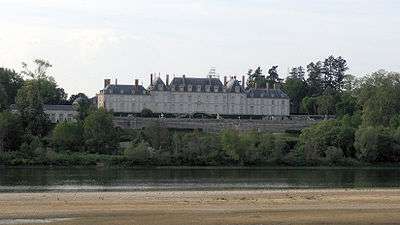
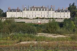
The château de Menars overlooking the Loire River
Menars is a commune in the Loir-et-Cher department of central France. The Château de Menars, formerly owned by Madame de Pompadour is located here.
See also
| Wikimedia Commons has media related to Menars. |
This article is issued from Wikipedia - version of the 3/1/2015. The text is available under the Creative Commons Attribution/Share Alike but additional terms may apply for the media files.