Brévainville
| Brévainville | ||
|---|---|---|
|
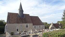
Church of Saint-Claude | ||
| ||
 Brévainville | ||
|
Location within Centre-Val de Loire region  Brévainville | ||
| Coordinates: 47°57′13″N 1°17′07″E / 47.9536°N 1.2853°ECoordinates: 47°57′13″N 1°17′07″E / 47.9536°N 1.2853°E | ||
| Country | France | |
| Region | Centre-Val de Loire | |
| Department | Loir-et-Cher | |
| Arrondissement | Vendôme | |
| Canton | Morée | |
| Intercommunality | Haut Vendômois | |
| Government | ||
| • Mayor (2014–2020) | Dominique Brunet | |
| Area1 | 16.16 km2 (6.24 sq mi) | |
| Population (2013)2 | 172 | |
| • Density | 11/km2 (28/sq mi) | |
| Time zone | CET (UTC+1) | |
| • Summer (DST) | CEST (UTC+2) | |
| INSEE/Postal code | 41026 / 41160 | |
| Elevation |
88–144 m (289–472 ft) (avg. 134 m or 440 ft) | |
|
1 French Land Register data, which excludes lakes, ponds, glaciers > 1 km² (0.386 sq mi or 247 acres) and river estuaries. 2 Population without double counting: residents of multiple communes (e.g., students and military personnel) only counted once. | ||

Brévainville is a commune in the Loir-et-Cher department in central France.
Population
| Historical population | ||
|---|---|---|
| Year | Pop. | ±% |
| 1793 | 175 | — |
| 1800 | 169 | −3.4% |
| 1806 | 190 | +12.4% |
| 1821 | 354 | +86.3% |
| 1831 | 353 | −0.3% |
| 1836 | 353 | +0.0% |
| 1841 | 362 | +2.5% |
| 1846 | 418 | +15.5% |
| 1851 | 401 | −4.1% |
| 1856 | 421 | +5.0% |
| 1861 | 402 | −4.5% |
| 1866 | 407 | +1.2% |
| 1872 | 386 | −5.2% |
| 1876 | 375 | −2.8% |
| 1881 | 354 | −5.6% |
| 1886 | 336 | −5.1% |
| 1891 | 368 | +9.5% |
| 1896 | 389 | +5.7% |
| 1901 | 402 | +3.3% |
| 1906 | 425 | +5.7% |
| 1911 | 444 | +4.5% |
| 1921 | 406 | −8.6% |
| 1926 | 356 | −12.3% |
| 1931 | 375 | +5.3% |
| 1936 | 364 | −2.9% |
| 1946 | 334 | −8.2% |
| 1954 | 304 | −9.0% |
| 1962 | 299 | −1.6% |
| 1968 | 256 | −14.4% |
| 1975 | 247 | −3.5% |
| 1982 | 206 | −16.6% |
| 1990 | 188 | −8.7% |
| 1999 | 163 | −13.3% |
| 2006 | 172 | +5.5% |
| 2009 | 172 | +0.0% |
See also
References
| Wikimedia Commons has media related to Brévainville. |
This article is issued from Wikipedia - version of the 11/10/2016. The text is available under the Creative Commons Attribution/Share Alike but additional terms may apply for the media files.