Saint-Viâtre
| Saint-Viâtre | ||
|---|---|---|
|
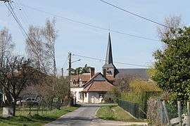
The church in Saint-Viâtre | ||
| ||
 Saint-Viâtre | ||
|
Location within Centre-Val de Loire region  Saint-Viâtre | ||
| Coordinates: 47°31′27″N 1°56′03″E / 47.5242°N 1.9342°ECoordinates: 47°31′27″N 1°56′03″E / 47.5242°N 1.9342°E | ||
| Country | France | |
| Region | Centre-Val de Loire | |
| Department | Loir-et-Cher | |
| Arrondissement | Romorantin-Lanthenay | |
| Canton | Salbris | |
| Intercommunality | Sologne des étangs | |
| Government | ||
| • Mayor (2008-2014) | Christian Léonard | |
| Area1 | 89.79 km2 (34.67 sq mi) | |
| Population (1999)2 | 1,157 | |
| • Density | 13/km2 (33/sq mi) | |
| Time zone | CET (UTC+1) | |
| • Summer (DST) | CEST (UTC+2) | |
| INSEE/Postal code | 41231 / 41210 | |
| Elevation |
92–132 m (302–433 ft) (avg. 108 m or 354 ft) | |
|
1 French Land Register data, which excludes lakes, ponds, glaciers > 1 km² (0.386 sq mi or 247 acres) and river estuaries. 2 Population without double counting: residents of multiple communes (e.g., students and military personnel) only counted once. | ||
.svg.png)
Saint-Viâtre is a commune in the Loir-et-Cher département of central France.
History
The village was originally called Tremblevif, from the Latin for "aspen" and "village", but suggesting in the popular imagination a place prone to swamp fever and trembling limbs. In 1854, worried that outsiders might be put off, the villagers successfully petitioned to change the name to Saint-Viâtre [1] in honour of a hermit, traditionally known as Viâtre, who had lived in the forests of Sologne. His tomb is in the crypt of the village church.
See also
References
- ↑ Graham Robb, The Discovery of France, Picador, London (2007), p.304, quoting Onésime Reclus. France, Algérie et colonies (1866), p.133
| Wikimedia Commons has media related to Saint-Viâtre. |
This article is issued from Wikipedia - version of the 3/15/2016. The text is available under the Creative Commons Attribution/Share Alike but additional terms may apply for the media files.