Droué
| Droué | ||
|---|---|---|
|
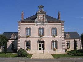
Town hall | ||
| ||
 Droué | ||
|
Location within Centre-Val de Loire region  Droué | ||
| Coordinates: 48°02′29″N 1°04′38″E / 48.0414°N 1.0772°ECoordinates: 48°02′29″N 1°04′38″E / 48.0414°N 1.0772°E | ||
| Country | France | |
| Region | Centre-Val de Loire | |
| Department | Loir-et-Cher | |
| Arrondissement | Vendôme | |
| Canton | Droué | |
| Intercommunality | Perche vendômois | |
| Government | ||
| • Mayor (2014–2020) | Yves Bertouy | |
| Area1 | 24.04 km2 (9.28 sq mi) | |
| Population (2013)2 | 1,013 | |
| • Density | 42/km2 (110/sq mi) | |
| Time zone | CET (UTC+1) | |
| • Summer (DST) | CEST (UTC+2) | |
| INSEE/Postal code | 41075 / 41260 | |
| Elevation |
143–214 m (469–702 ft) (avg. 158 m or 518 ft) | |
|
1 French Land Register data, which excludes lakes, ponds, glaciers > 1 km² (0.386 sq mi or 247 acres) and river estuaries. 2 Population without double counting: residents of multiple communes (e.g., students and military personnel) only counted once. | ||

.JPG)
Château de Droué
Droué is a commune in the Loir-et-Cher department of central France.
It is 65 km northwest of Blois and is bordered on the south by the Egvonne, a tributary of the Loir River.
Population
| Historical population | ||
|---|---|---|
| Year | Pop. | ±% |
| 1793 | 845 | — |
| 1806 | 794 | −6.0% |
| 1821 | 942 | +18.6% |
| 1831 | 961 | +2.0% |
| 1841 | 1,021 | +6.2% |
| 1851 | 1,049 | +2.7% |
| 1861 | 1,100 | +4.9% |
| 1872 | 1,005 | −8.6% |
| 1881 | 1,049 | +4.4% |
| 1891 | 1,119 | +6.7% |
| 1901 | 1,164 | +4.0% |
| 1911 | 1,239 | +6.4% |
| 1921 | 1,086 | −12.3% |
| 1931 | 1,132 | +4.2% |
| 1946 | 1,059 | −6.4% |
| 1954 | 1,013 | −4.3% |
| 1962 | 1,022 | +0.9% |
| 1968 | 1,065 | +4.2% |
| 1975 | 1,291 | +21.2% |
| 1982 | 1,322 | +2.4% |
| 1990 | 1,353 | +2.3% |
| 1999 | 1,205 | −10.9% |
| 2008 | 1,097 | −9.0% |
| 2013 | 1,013 | −7.7% |
International relations
It is twinned with Rothwell in the United Kingdom and Gondelsheim in Germany.
See also
References
External links
| Wikimedia Commons has media related to Droué. |
This article is issued from Wikipedia - version of the 11/22/2016. The text is available under the Creative Commons Attribution/Share Alike but additional terms may apply for the media files.