Thésée, Loir-et-Cher
| Thésée | |
|---|---|
|
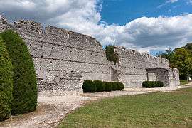
The Bâtiment des Maselles, Gallo-Roman ruins in Thésée | |
 Thésée | |
|
Location within Centre-Val de Loire region  Thésée | |
| Coordinates: 47°19′37″N 1°18′16″E / 47.3269°N 1.3044°ECoordinates: 47°19′37″N 1°18′16″E / 47.3269°N 1.3044°E | |
| Country | France |
| Region | Centre-Val de Loire |
| Department | Loir-et-Cher |
| Arrondissement | Romorantin-Lanthenay |
| Canton | Saint-Aignan |
| Intercommunality | Communauté de communes Val de Cher - Saint-Aignan |
| Government | |
| • Mayor | Daniel Charluteau |
| Area1 | 17.61 km2 (6.80 sq mi) |
| Population (1999)2 | 1,123 |
| • Density | 64/km2 (170/sq mi) |
| Time zone | CET (UTC+1) |
| • Summer (DST) | CEST (UTC+2) |
| INSEE/Postal code | 41258 / 41140 |
| Elevation |
61–122 m (200–400 ft) (avg. 70 m or 230 ft) |
|
1 French Land Register data, which excludes lakes, ponds, glaciers > 1 km² (0.386 sq mi or 247 acres) and river estuaries. 2 Population without double counting: residents of multiple communes (e.g., students and military personnel) only counted once. | |
Thésée is a commune of the Loir-et-Cher department in central France.
See also
| Wikimedia Commons has media related to Thésée (Loir-et-Cher). |
This article is issued from Wikipedia - version of the 3/2/2015. The text is available under the Creative Commons Attribution/Share Alike but additional terms may apply for the media files.