Condé-sur-Vire
| Conde-sur-Vire | |
|---|---|
 | |
 Conde-sur-Vire | |
|
Location within Normandy region  Conde-sur-Vire | |
| Coordinates: 49°03′11″N 1°02′09″W / 49.0531°N 1.0358°WCoordinates: 49°03′11″N 1°02′09″W / 49.0531°N 1.0358°W | |
| Country | France |
| Region | Normandy |
| Department | Manche |
| Arrondissement | Saint-Lô |
| Canton | Condé-sur-Vire |
| Intercommunality | Saint-Lô Agglo |
| Government | |
| • Mayor (2014–2020) | Laurent Pien |
| Area1 | 28.83 km2 (11.13 sq mi) |
| Population (2013)2 | 3,777 |
| • Density | 130/km2 (340/sq mi) |
| Time zone | CET (UTC+1) |
| • Summer (DST) | CEST (UTC+2) |
| INSEE/Postal code | 50139 / 50890 |
| Elevation |
17–153 m (56–502 ft) (avg. 28 m or 92 ft) |
| Website | www.conde-sur-vire.com |
|
1 French Land Register data, which excludes lakes, ponds, glaciers > 1 km² (0.386 sq mi or 247 acres) and river estuaries. 2 Population without double counting: residents of multiple communes (e.g., students and military personnel) only counted once. | |
Condé-sur-Vire is a commune in the Manche department in Normandy in north-western France. On 1 January 2016, the former commune of Le Mesnil-Raoult was merged into Condé-sur-Vire.[1]
Heraldry
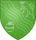 |
The arms of Condé-sur-Vire are blazoned : Vert, a bend wavy (river) between an enraged bull and a milk-can argent. |
People
Among well known people born here is Father Jean de Brébeuf, a martyr and since 1930 a Catholic saint.
Twinning
In the late 1970s, arrangements were made for the twinning of Condé-sur-Vire with the Parish of Whitehill, in Hampshire, UK. For several years, parties of civic leaders and school teachers would arrive in Bordon, accompanying 70 or more school children for a week of activities.
See also
References
- ↑ Arrêté préfectoral 28 September 2015
| Wikimedia Commons has media related to Condé-sur-Vire. |
This article is issued from Wikipedia - version of the 8/16/2016. The text is available under the Creative Commons Attribution/Share Alike but additional terms may apply for the media files.