Belleville-sur-Loire
| Belleville-sur-Loire | ||
|---|---|---|
|
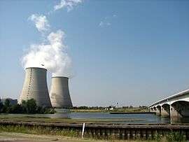
The nuclear plant at Belleville | ||
| ||
 Belleville-sur-Loire | ||
|
Location within Centre-Val de Loire region  Belleville-sur-Loire | ||
| Coordinates: 47°30′22″N 2°51′05″E / 47.5061°N 2.8514°ECoordinates: 47°30′22″N 2°51′05″E / 47.5061°N 2.8514°E | ||
| Country | France | |
| Region | Centre-Val de Loire | |
| Department | Cher | |
| Arrondissement | Bourges | |
| Canton | Léré | |
| Government | ||
| • Mayor (2008–2014) | Vincent Fregeai | |
| Area1 | 11 km2 (4 sq mi) | |
| Population (2008)2 | 1,034 | |
| • Density | 94/km2 (240/sq mi) | |
| Time zone | CET (UTC+1) | |
| • Summer (DST) | CEST (UTC+2) | |
| INSEE/Postal code | 18026 / 18240 | |
|
1 French Land Register data, which excludes lakes, ponds, glaciers > 1 km² (0.386 sq mi or 247 acres) and river estuaries. 2 Population without double counting: residents of multiple communes (e.g., students and military personnel) only counted once. | ||
.svg.png)
Belleville-sur-Loire is a commune in the Cher department in the Centre region of France.
Geography
A farming village with a nuclear power station situated by the banks of the river Loire, some 33 miles (53 km) northeast of Bourges at the junction of the D82, D951 and the D751 roads. The canal lateral a la Loire flows through the centre of the commune.
Population
| Historical population | ||
|---|---|---|
| Year | Pop. | ±% |
| 1962 | 340 | — |
| 1968 | 352 | +3.5% |
| 1975 | 288 | −18.2% |
| 1982 | 448 | +55.6% |
| 1990 | 1,009 | +125.2% |
| 1999 | 1,088 | +7.8% |
| 2008 | 1,034 | −5.0% |
Sights

Nuclear power station
- The church, dating from the twelfth century.
- Two chateaux, dating from the 15th and seventeenth century.
- Vestiges of Roman occupation.
- The nuclear power plant.
See also
References
External links
| Wikimedia Commons has media related to Belleville-sur-Loire. |
- Official website of Belleville sur Loire (French)
- Val de Jazz Festival website (French)
- Belleville-sur-Loire on the Quid website (French)
This article is issued from Wikipedia - version of the 10/30/2016. The text is available under the Creative Commons Attribution/Share Alike but additional terms may apply for the media files.