Sainte-Montaine
| Sainte-Montaine | |
|---|---|
|
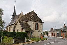
The church in Sainte-Montaine | |
 Sainte-Montaine | |
|
Location within Centre-Val de Loire region  Sainte-Montaine | |
| Coordinates: 47°29′28″N 2°19′15″E / 47.4911°N 2.3208°ECoordinates: 47°29′28″N 2°19′15″E / 47.4911°N 2.3208°E | |
| Country | France |
| Region | Centre-Val de Loire |
| Department | Cher |
| Arrondissement | Vierzon |
| Canton | Aubigny-sur-Nère |
| Intercommunality | Sauldre et Sologne |
| Government | |
| • Mayor (2008–2014) | Olivier Debarre |
| Area1 | 53.79 km2 (20.77 sq mi) |
| Population (2008)2 | 212 |
| • Density | 3.9/km2 (10/sq mi) |
| Time zone | CET (UTC+1) |
| • Summer (DST) | CEST (UTC+2) |
| INSEE/Postal code | 18227 / 18700 |
| Elevation |
133–183 m (436–600 ft) (avg. 167 m or 548 ft) |
|
1 French Land Register data, which excludes lakes, ponds, glaciers > 1 km² (0.386 sq mi or 247 acres) and river estuaries. 2 Population without double counting: residents of multiple communes (e.g., students and military personnel) only counted once. | |
Sainte-Montaine is a commune in the Cher department in the Centre region of France.
Geography
An area of streams, lakes, forestry and farming comprising a small village and two hamlets situated some 28 miles (45 km) north of Bourges at the junction of the D79, D180 and D13 roads. The small river Boute-Vive rises in the commune.
Population
| Historical population | ||
|---|---|---|
| Year | Pop. | ±% |
| 1962 | 216 | — |
| 1968 | 253 | +17.1% |
| 1975 | 226 | −10.7% |
| 1982 | 233 | +3.1% |
| 1990 | 206 | −11.6% |
| 1999 | 170 | −17.5% |
| 2008 | 212 | +24.7% |
Personalities
- Marguerite Audoux (1863- 1937), French novelist, lived here in her youth.
Sights
See also
References
External links
| Wikimedia Commons has media related to Sainte-Montaine. |
- Sainte-Montaine on the Quid website (French)
This article is issued from Wikipedia - version of the 2/28/2015. The text is available under the Creative Commons Attribution/Share Alike but additional terms may apply for the media files.