Bengy-sur-Craon
| Bengy-sur-Craon | |
|---|---|
|
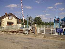
Railway station | |
 Bengy-sur-Craon | |
|
Location within Centre-Val de Loire region  Bengy-sur-Craon | |
| Coordinates: 47°00′04″N 2°44′55″E / 47.0011°N 2.7486°ECoordinates: 47°00′04″N 2°44′55″E / 47.0011°N 2.7486°E | |
| Country | France |
| Region | Centre-Val de Loire |
| Department | Cher |
| Arrondissement | Bourges |
| Canton | Baugy |
| Intercommunality | Pays de Nérondes |
| Government | |
| • Mayor (2014–2020) | Denis Durand |
| Area1 | 35.24 km2 (13.61 sq mi) |
| Population (2013)2 | 680 |
| • Density | 19/km2 (50/sq mi) |
| Time zone | CET (UTC+1) |
| • Summer (DST) | CEST (UTC+2) |
| INSEE/Postal code | 18027 / 18520 |
| Elevation |
173–230 m (568–755 ft) (avg. 186 m or 610 ft) |
|
1 French Land Register data, which excludes lakes, ponds, glaciers > 1 km² (0.386 sq mi or 247 acres) and river estuaries. 2 Population without double counting: residents of multiple communes (e.g., students and military personnel) only counted once. | |
Bengy-sur-Craon is a commune in the Cher department in the Centre region of France.
Geography
A farming area comprising the village and three hamlets situated by the banks of the river Craon, some 15 miles (24 km) southeast of Bourges at the junction of the D976 with the D102 and D10e roads. The commune is served by a TER railway link to Bourges.
The river Airain forms part of the commune's southeastern border.
Population
| Historical population | ||
|---|---|---|
| Year | Pop. | ±% |
| 1962 | 723 | — |
| 1968 | 700 | −3.2% |
| 1975 | 602 | −14.0% |
| 1982 | 584 | −3.0% |
| 1990 | 576 | −1.4% |
| 1999 | 609 | +5.7% |
| 2008 | 668 | +9.7% |
| 2013 | 680 | +1.8% |
Sights
- The oldest parts of the church of St.Pierre, the choir, dates from the twelfth century. The west door is 13th century. The two-storey bell tower, possibly inspired by an earlier form, is modern. It has been listed since 1913 as a monument historique by the French Ministry of Culture.[1]
- Roman remains, including a mosaic.
- A barn at Champ des Vignes, built 1731, is typical of the region. It has been listed since 1989 as a monument historique.[2]
- The medieval site at Bouchetin.
See also
References
- ↑ Ministry of Culture: Eglise Saint-Pierre (French)
- ↑ Ministry of Culture: Grange (French)
External links
| Wikimedia Commons has media related to Bengy-sur-Craon. |
- Bengy-sur-Craon on the Quid website (French)
- Ministry of Culture listing for St Pierre church (French) and Ministry of Culture photos
- Ministry of Culture listing for 18th century barn (French)
This article is issued from Wikipedia - version of the 6/2/2016. The text is available under the Creative Commons Attribution/Share Alike but additional terms may apply for the media files.