Lury-sur-Arnon
| Lury-sur-Arnon | ||
|---|---|---|
 | ||
| ||
 Lury-sur-Arnon | ||
|
Location within Centre-Val de Loire region  Lury-sur-Arnon | ||
| Coordinates: 47°07′42″N 2°03′28″E / 47.1283°N 2.0578°ECoordinates: 47°07′42″N 2°03′28″E / 47.1283°N 2.0578°E | ||
| Country | France | |
| Region | Centre-Val de Loire | |
| Department | Cher | |
| Arrondissement | Vierzon | |
| Canton | Lury-sur-Arnon | |
| Intercommunality | Vals de Cher et d'Arnon | |
| Government | ||
| • Mayor (2008–2014) | Jean-Claude Fagot | |
| Area1 | 13.84 km2 (5.34 sq mi) | |
| Population (2008)2 | 681 | |
| • Density | 49/km2 (130/sq mi) | |
| Time zone | CET (UTC+1) | |
| • Summer (DST) | CEST (UTC+2) | |
| INSEE/Postal code | 18134 / 18120 | |
| Elevation |
103–138 m (338–453 ft) (avg. 115 m or 377 ft) | |
|
1 French Land Register data, which excludes lakes, ponds, glaciers > 1 km² (0.386 sq mi or 247 acres) and river estuaries. 2 Population without double counting: residents of multiple communes (e.g., students and military personnel) only counted once. | ||
.svg.png)
Lury-sur-Arnon is a commune in the Cher department in the Centre region of France.
Geography
An ancient fortified farming village situated by the river Arnon, some 7 miles (11 km) south of Vierzon at the junction of the D30, D918 and the D68 roads.
Population
| Historical population | ||
|---|---|---|
| Year | Pop. | ±% |
| 1962 | 611 | — |
| 1968 | 612 | +0.2% |
| 1975 | 528 | −13.7% |
| 1982 | 566 | +7.2% |
| 1990 | 644 | +13.8% |
| 1999 | 671 | +4.2% |
| 2008 | 681 | +1.5% |
Sights
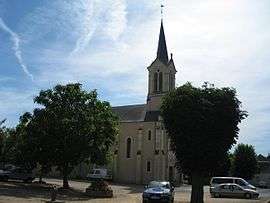
- The church of St. Paul, dating from the nineteenth century.
- The castle, dating from the twelfth century.
- The restored Gothic chapel.
- A twelfth-century gatehouse tower.
See also
References
External links
| Wikimedia Commons has media related to Lury-sur-Arnon. |
- Lury-sur-Arnon on the Quid website (French)
This article is issued from Wikipedia - version of the 2/11/2016. The text is available under the Creative Commons Attribution/Share Alike but additional terms may apply for the media files.