Arçay, Cher
| Arçay | |
|---|---|
|
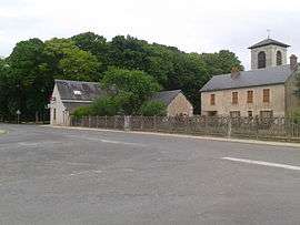
The main square in Arçay | |
 Arçay | |
|
Location within Centre-Val de Loire region  Arçay | |
| Coordinates: 46°56′57″N 2°20′28″E / 46.9492°N 2.3411°ECoordinates: 46°56′57″N 2°20′28″E / 46.9492°N 2.3411°E | |
| Country | France |
| Region | Centre-Val de Loire |
| Department | Cher |
| Arrondissement | Bourges |
| Canton | Levet |
| Intercommunality | Bourges Plus |
| Government | |
| • Mayor (2001–2008) | Robert Huchins |
| Area1 | 18.32 km2 (7.07 sq mi) |
| Population (2008)2 | 495 |
| • Density | 27/km2 (70/sq mi) |
| Time zone | CET (UTC+1) |
| • Summer (DST) | CEST (UTC+2) |
| INSEE/Postal code | 18008 / 18340 |
| Elevation | 145–174 m (476–571 ft) |
|
1 French Land Register data, which excludes lakes, ponds, glaciers > 1 km² (0.386 sq mi or 247 acres) and river estuaries. 2 Population without double counting: residents of multiple communes (e.g., students and military personnel) only counted once. | |
Arçay is a commune in the Cher department in the Centre region of France.
Geography
A farming area comprising the village and several hamlets situated some 12 miles (19 km) south of Bourges at the junction of the D88, D28 and the D73 roads.
Population
The inhabitants are called Arcéens or Arcéennes.
| Historical population | ||
|---|---|---|
| Year | Pop. | ±% |
| 1962 | 249 | — |
| 1968 | 258 | +3.6% |
| 1975 | 222 | −14.0% |
| 1982 | 337 | +51.8% |
| 1990 | 378 | +12.2% |
| 1999 | 377 | −0.3% |
| 2008 | 495 | +31.3% |
Places of interest
- The church of St.Sulpice, dating from the nineteenth century.
- The nineteenth-century château Belair.
See also
References
External links
| Wikimedia Commons has media related to Arçay (Cher). |
- Arçay on the Quid website (French)
This article is issued from Wikipedia - version of the 10/19/2016. The text is available under the Creative Commons Attribution/Share Alike but additional terms may apply for the media files.