Vorly
| Vorly | |
|---|---|
|
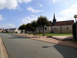
The church in Vorly | |
 Vorly | |
|
Location within Centre-Val de Loire region  Vorly | |
| Coordinates: 46°56′46″N 2°27′57″E / 46.9461°N 2.4658°ECoordinates: 46°56′46″N 2°27′57″E / 46.9461°N 2.4658°E | |
| Country | France |
| Region | Centre-Val de Loire |
| Department | Cher |
| Arrondissement | Bourges |
| Canton | Levet |
| Intercommunality | Les Rampennes |
| Government | |
| • Mayor (2008–2014) | Evelyne Martin-Tillier |
| Area1 | 18.84 km2 (7.27 sq mi) |
| Population (2008)2 | 245 |
| • Density | 13/km2 (34/sq mi) |
| Time zone | CET (UTC+1) |
| • Summer (DST) | CEST (UTC+2) |
| INSEE/Postal code | 18288 / 18340 |
| Elevation |
154–184 m (505–604 ft) (avg. 178 m or 584 ft) |
|
1 French Land Register data, which excludes lakes, ponds, glaciers > 1 km² (0.386 sq mi or 247 acres) and river estuaries. 2 Population without double counting: residents of multiple communes (e.g., students and military personnel) only counted once. | |
Vorly is a commune in the Cher department in the Centre region of France.
Geography
An area of forestry and farming comprising the village and a couple of hamlets situated about 10 miles (16 km) south of Bourges, at the junction of the D34 with the D71 road.
Population
| Historical population | ||
|---|---|---|
| Year | Pop. | ±% |
| 1962 | 325 | — |
| 1968 | 300 | −7.7% |
| 1975 | 286 | −4.7% |
| 1982 | 254 | −11.2% |
| 1990 | 263 | +3.5% |
| 1999 | 249 | −5.3% |
| 2008 | 245 | −1.6% |
Sights
- The church of St. Saturnin, dating from the fifteenth century.
- The fourteenth-century chateau of Bois-Sir-Amé.
- A feudal motte.
See also
References
External links
| Wikimedia Commons has media related to Vorly. |
- Vorly on the Quid website (French)
This article is issued from Wikipedia - version of the 9/10/2016. The text is available under the Creative Commons Attribution/Share Alike but additional terms may apply for the media files.