Drevant
| Drevant | |
|---|---|
|
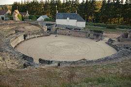
Roman amphitheatre | |
 Drevant | |
|
Location within Centre-Val de Loire region  Drevant | |
| Coordinates: 46°41′39″N 2°31′33″E / 46.6942°N 2.5258°ECoordinates: 46°41′39″N 2°31′33″E / 46.6942°N 2.5258°E | |
| Country | France |
| Region | Centre-Val de Loire |
| Department | Cher |
| Arrondissement | Saint-Amand-Montrond |
| Canton | Saint-Amand-Montrond |
| Intercommunality | Cœur de France |
| Government | |
| • Mayor (2008–2014) | Bernard Jamet |
| Area1 | 4.84 km2 (1.87 sq mi) |
| Population (2008)2 | 589 |
| • Density | 120/km2 (320/sq mi) |
| Time zone | CET (UTC+1) |
| • Summer (DST) | CEST (UTC+2) |
| INSEE/Postal code | 18086 / 18200 |
| Elevation |
153–250 m (502–820 ft) (avg. 168 m or 551 ft) |
|
1 French Land Register data, which excludes lakes, ponds, glaciers > 1 km² (0.386 sq mi or 247 acres) and river estuaries. 2 Population without double counting: residents of multiple communes (e.g., students and military personnel) only counted once. | |
Drevant is a commune in the Cher department in the Centre region of France.
Geography
A farming village situated by the banks of the river Cher some 26 miles (42 km) south of Bourges at the junction of the D97 with the D141 and D2144 roads.
Population
| Historical population | ||
|---|---|---|
| Year | Pop. | ±% |
| 1962 | 260 | — |
| 1968 | 283 | +8.8% |
| 1975 | 355 | +25.4% |
| 1982 | 486 | +36.9% |
| 1990 | 533 | +9.7% |
| 1999 | 610 | +14.4% |
| 2008 | 589 | −3.4% |
Sights
- The church of St. Pierre, dating from the twelfth century.
- The chapel of the eleventh-century priory.
- Considerable Gallo-Roman remains, including an amphitheatre, baths, villas and an aqueduct.
See also
References
External links
| Wikimedia Commons has media related to Drevant. |
- Drevant on the Quid website (French)
This article is issued from Wikipedia - version of the 2/27/2015. The text is available under the Creative Commons Attribution/Share Alike but additional terms may apply for the media files.