Culan
For the mountain, see Culan (mountain).
| Culan | ||
|---|---|---|
|
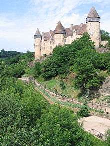
The Château de Culan | ||
| ||
 Culan | ||
|
Location within Centre-Val de Loire region  Culan | ||
| Coordinates: 46°32′54″N 2°21′00″E / 46.5483°N 2.35°ECoordinates: 46°32′54″N 2°21′00″E / 46.5483°N 2.35°E | ||
| Country | France | |
| Region | Centre-Val de Loire | |
| Department | Cher | |
| Arrondissement | Saint-Amand-Montrond | |
| Canton | Châteaumeillant | |
| Government | ||
| • Mayor (2011–2014) | Jean-Claude Gross | |
| Area1 | 20.23 km2 (7.81 sq mi) | |
| Population (2008)2 | 796 | |
| • Density | 39/km2 (100/sq mi) | |
| Time zone | CET (UTC+1) | |
| • Summer (DST) | CEST (UTC+2) | |
| INSEE/Postal code | 18083 / 18270 | |
| Elevation |
220–332 m (722–1,089 ft) (avg. 270 m or 890 ft) | |
|
1 French Land Register data, which excludes lakes, ponds, glaciers > 1 km² (0.386 sq mi or 247 acres) and river estuaries. 2 Population without double counting: residents of multiple communes (e.g., students and military personnel) only counted once. | ||
.svg.png)
Culan is a commune in the Cher département in the Centre region of France.
It is best known for its 12th-15th century medieval castle, the Château de Culan, one of the oldest castles still occupied in the world. The castle has beautiful medieval gardens and it is open to visitors every day from Easter until November.
Geography
The commune is a farming area comprising the village and a few hamlets situated by the banks of the Arnon river, in the south of the département some 35 miles (56 km) south of Bourges and at the junction of the D997 with the D943, D4 and D65 roads.
Population
| Historical population | ||
|---|---|---|
| Year | Pop. | ±% |
| 1962 | 1,261 | — |
| 1968 | 1,310 | +3.9% |
| 1975 | 1,164 | −11.1% |
| 1982 | 1,055 | −9.4% |
| 1990 | 932 | −11.7% |
| 1999 | 822 | −11.8% |
| 2008 | 796 | −3.2% |
Sights
- The church of St. Vincent, dating from the seventeenth century
- The castle
- A watermill
- A nineteenth-century viaduct
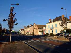
The village of Culan
See also
References
External links
| Wikimedia Commons has media related to Culan. |
- Website of the Château de Culan (French)
- Culan on the Quid website (French)
This article is issued from Wikipedia - version of the 6/22/2015. The text is available under the Creative Commons Attribution/Share Alike but additional terms may apply for the media files.