Poisieux
| Poisieux | |
|---|---|
|
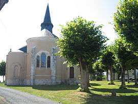
The church in Poisieux | |
 Poisieux | |
|
Location within Centre-Val de Loire region  Poisieux | |
| Coordinates: 47°01′48″N 2°05′56″E / 47.03°N 2.0989°ECoordinates: 47°01′48″N 2°05′56″E / 47.03°N 2.0989°E | |
| Country | France |
| Region | Centre-Val de Loire |
| Department | Cher |
| Arrondissement | Bourges |
| Canton | Chârost |
| Intercommunality | Vals de Cher et d'Arnon |
| Government | |
| • Mayor (2008–2014) | Jacques Ménigon |
| Area1 | 10.3 km2 (4.0 sq mi) |
| Population (2008)2 | 209 |
| • Density | 20/km2 (53/sq mi) |
| Time zone | CET (UTC+1) |
| • Summer (DST) | CEST (UTC+2) |
| INSEE/Postal code | 18182 / 18290 |
| Elevation |
113–152 m (371–499 ft) (avg. 145 m or 476 ft) |
|
1 French Land Register data, which excludes lakes, ponds, glaciers > 1 km² (0.386 sq mi or 247 acres) and river estuaries. 2 Population without double counting: residents of multiple communes (e.g., students and military personnel) only counted once. | |
Poisieux is a commune in the Cher department in the Centre region of France.
It is a small farming village situated by the banks of the river Arnon. It borders with the department of Indre, some 14 miles (23 km) southwest of Bourges, at the junction of the D190 and the D18 roads.
Population
| Historical population | ||
|---|---|---|
| Year | Pop. | ±% |
| 1962 | 180 | — |
| 1968 | 212 | +17.8% |
| 1975 | 210 | −0.9% |
| 1982 | 167 | −20.5% |
| 1990 | 155 | −7.2% |
| 1999 | 158 | +1.9% |
| 2008 | 209 | +32.3% |
Sights
- The church, dating from the nineteenth century.
- The chateau of Mazières.
See also
References
External links
| Wikimedia Commons has media related to Poisieux. |
This article is issued from Wikipedia - version of the 2/27/2015. The text is available under the Creative Commons Attribution/Share Alike but additional terms may apply for the media files.