Châteaumeillant
| Châteaumeillant | ||
|---|---|---|
|
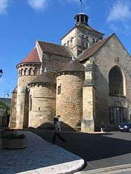
The church of Our Lady, in Châteaumeillant | ||
| ||
 Châteaumeillant | ||
|
Location within Centre-Val de Loire region  Châteaumeillant | ||
| Coordinates: 46°33′46″N 2°12′05″E / 46.5628°N 2.2014°ECoordinates: 46°33′46″N 2°12′05″E / 46.5628°N 2.2014°E | ||
| Country | France | |
| Region | Centre-Val de Loire | |
| Department | Cher | |
| Arrondissement | Saint-Amand-Montrond | |
| Canton | Châteaumeillant | |
| Government | ||
| • Mayor (2008–2014) | Guy Bergerault | |
| Area1 | 42.48 km2 (16.40 sq mi) | |
| Population (2008)2 | 2,082 | |
| • Density | 49/km2 (130/sq mi) | |
| Time zone | CET (UTC+1) | |
| • Summer (DST) | CEST (UTC+2) | |
| INSEE/Postal code | 18057 / 18370 | |
| Elevation |
212–388 m (696–1,273 ft) (avg. 253 m or 830 ft) | |
|
1 French Land Register data, which excludes lakes, ponds, glaciers > 1 km² (0.386 sq mi or 247 acres) and river estuaries. 2 Population without double counting: residents of multiple communes (e.g., students and military personnel) only counted once. | ||
.svg.png)
Châteaumeillant is a commune in the Cher department in the Centre region of France.
Geography
An area of winegrowing, farming and forestry comprising a small town and several hamlets situated in the valley of the small river Sinaise, some 40 miles (64 km) south of Bourges at the junction of the D943 with the D3 and the D70 roads.
Population
| Historical population | ||
|---|---|---|
| Year | Pop. | ±% |
| 1962 | 2,462 | — |
| 1968 | 2,528 | +2.7% |
| 1975 | 2,429 | −3.9% |
| 1982 | 2,186 | −10.0% |
| 1990 | 2,081 | −4.8% |
| 1999 | 2,058 | −1.1% |
| 2008 | 2,082 | +1.2% |
Sights
- The abbey church of St. Genès, dating from the twelfth century.
- A medieval castle.
- Other buildings, originally part of the abbey.
- The museum, dating from the fourteenth century.
- The eleventh-century church of Notre-Dame.

The vineyards of Châteaumeillant
See also
References
External links
| Wikimedia Commons has media related to Châteaumeillant. |
- Official town website (French)
- Website of the winegrowing cooperative (French)
- Châteaumeillant on the Quid website (French)
This article is issued from Wikipedia - version of the 2/27/2015. The text is available under the Creative Commons Attribution/Share Alike but additional terms may apply for the media files.