Chambon, Cher
| Chambon | |
|---|---|
|
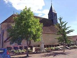
The church of Saint-Pierre, in Chambon | |
 Chambon | |
|
Location within Centre-Val de Loire region  Chambon | |
| Coordinates: 46°47′16″N 2°19′32″E / 46.7878°N 2.3256°ECoordinates: 46°47′16″N 2°19′32″E / 46.7878°N 2.3256°E | |
| Country | France |
| Region | Centre-Val de Loire |
| Department | Cher |
| Arrondissement | Saint-Amand-Montrond |
| Canton | Châteauneuf-sur-Cher |
| Intercommunality | Portes du Boischaut |
| Government | |
| • Mayor (2008–2014) | Gérard Lucas |
| Area1 | 13.91 km2 (5.37 sq mi) |
| Population (2008)2 | 148 |
| • Density | 11/km2 (28/sq mi) |
| Time zone | CET (UTC+1) |
| • Summer (DST) | CEST (UTC+2) |
| INSEE/Postal code | 18046 / 18190 |
| Elevation |
147–187 m (482–614 ft) (avg. 170 m or 560 ft) |
|
1 French Land Register data, which excludes lakes, ponds, glaciers > 1 km² (0.386 sq mi or 247 acres) and river estuaries. 2 Population without double counting: residents of multiple communes (e.g., students and military personnel) only counted once. | |
Chambon is a commune in the Cher department in the Centre region of France.
Geography
A small farming village situated by the banks of the river Trian some 21 miles (34 km) south of Bourges at the junction of the D73 with the D192 road.
Population
| Historical population | ||
|---|---|---|
| Year | Pop. | ±% |
| 1962 | 215 | — |
| 1968 | 231 | +7.4% |
| 1975 | 195 | −15.6% |
| 1982 | 143 | −26.7% |
| 1990 | 122 | −14.7% |
| 1999 | 134 | +9.8% |
| 2008 | 148 | +10.4% |
Sights
- The church of St. Pierre, dating from the twelfth century
See also
References
External links
| Wikimedia Commons has media related to Chambon (Cher). |
- Chambon on the Quid website (French)
This article is issued from Wikipedia - version of the 11/19/2016. The text is available under the Creative Commons Attribution/Share Alike but additional terms may apply for the media files.