Le Noyer, Cher
| Le Noyer | |
|---|---|
|
| |
 Le Noyer | |
|
Location within Centre-Val de Loire region  Le Noyer | |
| Coordinates: 47°23′06″N 2°40′54″E / 47.385°N 2.6817°ECoordinates: 47°23′06″N 2°40′54″E / 47.385°N 2.6817°E | |
| Country | France |
| Region | Centre-Val de Loire |
| Department | Cher |
| Arrondissement | Bourges |
| Canton | Vailly-sur-Sauldre |
| Intercommunality | Cœur du Pays Fort |
| Government | |
| • Mayor (2008–2014) | Chantal Millerioux |
| Area1 | 19.98 km2 (7.71 sq mi) |
| Population (2008)2 | 275 |
| • Density | 14/km2 (36/sq mi) |
| Time zone | CET (UTC+1) |
| • Summer (DST) | CEST (UTC+2) |
| INSEE/Postal code | 18168 / 18260 |
| Elevation |
208–374 m (682–1,227 ft) (avg. 260 m or 850 ft) |
|
1 French Land Register data, which excludes lakes, ponds, glaciers > 1 km² (0.386 sq mi or 247 acres) and river estuaries. 2 Population without double counting: residents of multiple communes (e.g., students and military personnel) only counted once. | |
Le Noyer is a commune in the Cher department in the Centre region of France.
Geography
An area of forestry and farming comprising the village and a couple of hamlets situated in the valley of the Sauldre river, some 27 miles (43 km) northeast of Bourges, at the junction of the D55, D85, D94 and the D74 roads.
Population
| Historical population | ||
|---|---|---|
| Year | Pop. | ±% |
| 1962 | 305 | — |
| 1968 | 398 | +30.5% |
| 1975 | 350 | −12.1% |
| 1982 | 296 | −15.4% |
| 1990 | 265 | −10.5% |
| 1999 | 266 | +0.4% |
| 2008 | 275 | +3.4% |
Sights
- A seventeenth-century farm and mill.
- The church of Notre-Dame, dating from the twelfth century.
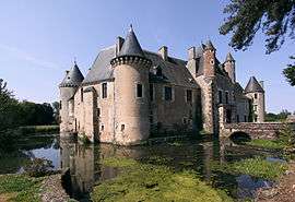
- The chateau of Boucard, rebuilt in the sixteenth century over the feudal castle.
See also
References
External links
| Wikimedia Commons has media related to Le Noyer (Cher). |
- Le Noyer on the Quid website (French)
This article is issued from Wikipedia - version of the 11/2/2014. The text is available under the Creative Commons Attribution/Share Alike but additional terms may apply for the media files.