Primelles
| Primelles | |
|---|---|
|
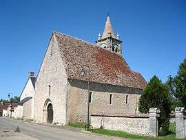
The church of Saint-Laurent, in Primelles | |
 Primelles | |
|
Location within Centre-Val de Loire region  Primelles | |
| Coordinates: 46°55′45″N 2°12′50″E / 46.9292°N 2.2139°ECoordinates: 46°55′45″N 2°12′50″E / 46.9292°N 2.2139°E | |
| Country | France |
| Region | Centre-Val de Loire |
| Department | Cher |
| Arrondissement | Bourges |
| Canton | Chârost |
| Intercommunality | Fercher - Pays florentais |
| Government | |
| • Mayor (2008–2014) | Michel Bonnet |
| Area1 | 26.57 km2 (10.26 sq mi) |
| Population (2008)2 | 256 |
| • Density | 9.6/km2 (25/sq mi) |
| Time zone | CET (UTC+1) |
| • Summer (DST) | CEST (UTC+2) |
| INSEE/Postal code | 18188 / 18400 |
| Elevation |
133–173 m (436–568 ft) (avg. 151 m or 495 ft) |
|
1 French Land Register data, which excludes lakes, ponds, glaciers > 1 km² (0.386 sq mi or 247 acres) and river estuaries. 2 Population without double counting: residents of multiple communes (e.g., students and military personnel) only counted once. | |
Primelles is a commune in the Cher department in the Centre region of France.
Geography
An area of forestry and farming comprising two villages and a couple of hamlets, situated on the banks of the river Pontet, some 17 miles (27 km) southwest of Bourges, at the junction of the D99 and the D87 roads.
Population
| Historical population | ||||||||||||||||||||||||||||
|---|---|---|---|---|---|---|---|---|---|---|---|---|---|---|---|---|---|---|---|---|---|---|---|---|---|---|---|---|
|
| |||||||||||||||||||||||||||
Sights
See also
References
External links
| Wikimedia Commons has media related to Primelles. |
- Primelles on the Quid website (French)
This article is issued from Wikipedia - version of the 5/5/2016. The text is available under the Creative Commons Attribution/Share Alike but additional terms may apply for the media files.