Nérondes
| Nérondes | ||
|---|---|---|
|
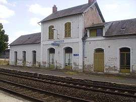
Railway station | ||
| ||
 Nérondes | ||
|
Location within Centre-Val de Loire region  Nérondes | ||
| Coordinates: 46°59′54″N 2°49′13″E / 46.9983°N 2.8203°ECoordinates: 46°59′54″N 2°49′13″E / 46.9983°N 2.8203°E | ||
| Country | France | |
| Region | Centre-Val de Loire | |
| Department | Cher | |
| Arrondissement | Saint-Amand-Montrond | |
| Canton | Nérondes | |
| Intercommunality | Pays de Nérondes | |
| Government | ||
| • Mayor (2008–2014) | Alain Laroche | |
| Area1 | 34 km2 (13 sq mi) | |
| Population (2008)2 | 1,486 | |
| • Density | 44/km2 (110/sq mi) | |
| Time zone | CET (UTC+1) | |
| • Summer (DST) | CEST (UTC+2) | |
| INSEE/Postal code | 18160 / 18350 | |
| Elevation |
176–252 m (577–827 ft) (avg. 189 m or 620 ft) | |
|
1 French Land Register data, which excludes lakes, ponds, glaciers > 1 km² (0.386 sq mi or 247 acres) and river estuaries. 2 Population without double counting: residents of multiple communes (e.g., students and military personnel) only counted once. | ||
.svg.png)
Nérondes is a commune in the Cher department in the Centre region of France. The philologist Antoine Cabaton (1863–1942) was born in Nérondes.
Geography
An area of lakes and streams, forestry and farming comprising a village and several hamlets situated some 20 miles (32 km) southeast of Bourges, at the junction of the D976 with the D6, D26 and D43 roads. The rivers Vauvise and Airain have their sources in the commune.
Population
| Historical population | ||
|---|---|---|
| Year | Pop. | ±% |
| 1962 | 1,111 | — |
| 1968 | 1,306 | +17.6% |
| 1975 | 1,305 | −0.1% |
| 1982 | 1,343 | +2.9% |
| 1990 | 1,521 | +13.3% |
| 1999 | 1,618 | +6.4% |
| 2008 | 1,486 | −8.2% |
Sights
- The church of St. Etienne, dating from the twelfth century.
- A sixteenth-century washhouse.
- The thirteenth-century chateau of Verrières.
- Some Gallo-Roman remains.
- A feudal motte.
See also
External links
| Wikimedia Commons has media related to Nérondes. |
- INSEE
- Official website of the commune (French)
- Annuaire Marie website (French)
- Nérondes on the Quid website (French)
This article is issued from Wikipedia - version of the 10/15/2016. The text is available under the Creative Commons Attribution/Share Alike but additional terms may apply for the media files.