Lazenay
| Lazenay | |
|---|---|
|
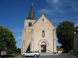
The church in Lazenay | |
 Lazenay | |
|
Location within Centre-Val de Loire region  Lazenay | |
| Coordinates: 47°04′19″N 2°03′41″E / 47.0719°N 2.0614°ECoordinates: 47°04′19″N 2°03′41″E / 47.0719°N 2.0614°E | |
| Country | France |
| Region | Centre-Val de Loire |
| Department | Cher |
| Arrondissement | Vierzon |
| Canton | Lury-sur-Arnon |
| Intercommunality | Vals de Cher et d'Arnon |
| Government | |
| • Mayor (2001–2008) | Bernard Aujard |
| Area1 | 30.74 km2 (11.87 sq mi) |
| Population (2008)2 | 355 |
| • Density | 12/km2 (30/sq mi) |
| Time zone | CET (UTC+1) |
| • Summer (DST) | CEST (UTC+2) |
| INSEE/Postal code | 18124 / 18120 |
| Elevation |
107–153 m (351–502 ft) (avg. 210 m or 690 ft) |
|
1 French Land Register data, which excludes lakes, ponds, glaciers > 1 km² (0.386 sq mi or 247 acres) and river estuaries. 2 Population without double counting: residents of multiple communes (e.g., students and military personnel) only counted once. | |
Lazenay is a commune in the Cher department in the Centre region of France.
Geography
A farming area comprising the village and a couple of hamlets, situated at the confluence of the rivers Arnon and Théols, some 12 miles (19 km) south of Vierzon at the junction of the D18, D23, D918 and the D229 roads.
Population
| Historical population | ||
|---|---|---|
| Year | Pop. | ±% |
| 1962 | 387 | — |
| 1968 | 413 | +6.7% |
| 1975 | 337 | −18.4% |
| 1982 | 300 | −11.0% |
| 1990 | 326 | +8.7% |
| 1999 | 354 | +8.6% |
| 2008 | 355 | +0.3% |
Sights
- The church of Notre-Dame, dating from the sixteenth century.
- The château of La Ferté, built in 1659.
- Two watermills.
Personalities
- Rémy Pointereau, politician, was born here on 30 March 1953.
See also
References
External links
| Wikimedia Commons has media related to Lazenay. |
- Lazenay on the Quid website (French)
This article is issued from Wikipedia - version of the 2/27/2015. The text is available under the Creative Commons Attribution/Share Alike but additional terms may apply for the media files.