Azillanet
| Azillanet | ||
|---|---|---|
|
Saint-Laurent Church | ||
| ||
 Azillanet | ||
|
Location within Occitanie region  Azillanet | ||
| Coordinates: 43°19′30″N 2°44′18″E / 43.325°N 2.7383°ECoordinates: 43°19′30″N 2°44′18″E / 43.325°N 2.7383°E | ||
| Country | France | |
| Region | Occitanie | |
| Department | Hérault | |
| Arrondissement | Béziers | |
| Canton | Olonzac | |
| Intercommunality | Minervois | |
| Government | ||
| • Mayor (2008–2014) | Martine Olmos | |
| Area1 | 14.4 km2 (5.6 sq mi) | |
| Population (2008)2 | 407 | |
| • Density | 28/km2 (73/sq mi) | |
| Time zone | CET (UTC+1) | |
| • Summer (DST) | CEST (UTC+2) | |
| INSEE/Postal code | 34020 / 34210 | |
| Elevation |
62–279 m (203–915 ft) (avg. 100 m or 330 ft) | |
|
1 French Land Register data, which excludes lakes, ponds, glaciers > 1 km² (0.386 sq mi or 247 acres) and river estuaries. 2 Population without double counting: residents of multiple communes (e.g., students and military personnel) only counted once. | ||

.svg.png)
Azillanet (Asilhanet in Occitan) is a commune in the Hérault department in southern France.
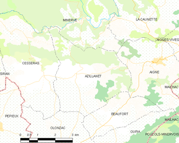
Map
Population
| Historical population | ||
|---|---|---|
| Year | Pop. | ±% |
| 1962 | 430 | — |
| 1968 | 468 | +8.8% |
| 1975 | 384 | −17.9% |
| 1982 | 371 | −3.4% |
| 1990 | 331 | −10.8% |
| 1999 | 370 | +11.8% |
| 2008 | 407 | +10.0% |
See also
References
| Wikimedia Commons has media related to Azillanet. |
This article is issued from Wikipedia - version of the 3/15/2016. The text is available under the Creative Commons Attribution/Share Alike but additional terms may apply for the media files.