Pouzolles
| Pouzolles | ||
|---|---|---|
|
A general view of Pouzolles | ||
| ||
 Pouzolles | ||
|
Location within Occitanie region  Pouzolles | ||
| Coordinates: 43°29′03″N 3°16′47″E / 43.4842°N 3.2797°ECoordinates: 43°29′03″N 3°16′47″E / 43.4842°N 3.2797°E | ||
| Country | France | |
| Region | Occitanie | |
| Department | Hérault | |
| Arrondissement | Béziers | |
| Canton | Roujan | |
| Intercommunality | Communauté de communes des Avant-Monts du Centre Hérault | |
| Government | ||
| • Mayor (2008–2014) | Guy Roucayrol | |
| Area1 | 10.01 km2 (3.86 sq mi) | |
| Population (2008)2 | 1,029 | |
| • Density | 100/km2 (270/sq mi) | |
| Time zone | CET (UTC+1) | |
| • Summer (DST) | CEST (UTC+2) | |
| INSEE/Postal code | 34214 / 34480 | |
| Elevation |
48–180 m (157–591 ft) (avg. 90 m or 300 ft) | |
|
1 French Land Register data, which excludes lakes, ponds, glaciers > 1 km² (0.386 sq mi or 247 acres) and river estuaries. 2 Population without double counting: residents of multiple communes (e.g., students and military personnel) only counted once. | ||

.svg.png)
Pouzolles (Posòlas in occitan) is a commune in the Hérault department in the Occitanie region in southern France.
Activities
The village has a small collection of a few shops (bakery, superette, tobacconist), a pizzeria and chambres d'hôtes, or gîtes. These come along with various other activities, such as a post office, a nearby paintball, a seasonal gallery and of course the local wines.
Sights
- the château (see on pictures).
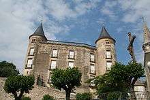
View of the Château
- the village center, built as a circulade.
Population
| Historical population | ||
|---|---|---|
| Year | Pop. | ±% |
| 1962 | 833 | — |
| 1968 | 855 | +2.6% |
| 1975 | 788 | −7.8% |
| 1982 | 765 | −2.9% |
| 1990 | 762 | −0.4% |
| 1999 | 781 | +2.5% |
| 2008 | 1,029 | +31.8% |
See also
References
External links
| Wikimedia Commons has media related to Pouzolles. |
- Official website (French)
- Coteaux et Châteaux website (French)
This article is issued from Wikipedia - version of the 11/12/2016. The text is available under the Creative Commons Attribution/Share Alike but additional terms may apply for the media files.