Prémian
| Prémian | ||
|---|---|---|
|
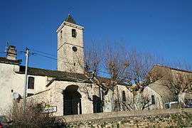
The church of Saint-Sébastien | ||
| ||
 Prémian | ||
|
Location within Occitanie region  Prémian | ||
| Coordinates: 43°31′30″N 2°49′52″E / 43.525°N 2.8311°ECoordinates: 43°31′30″N 2°49′52″E / 43.525°N 2.8311°E | ||
| Country | France | |
| Region | Occitanie | |
| Department | Hérault | |
| Arrondissement | Béziers | |
| Canton | Olargues | |
| Intercommunality | Orb et Jaur | |
| Government | ||
| • Mayor (2008–2014) | Hubert Barthes | |
| Area1 | 16.69 km2 (6.44 sq mi) | |
| Population (2008)2 | 511 | |
| • Density | 31/km2 (79/sq mi) | |
| Time zone | CET (UTC+1) | |
| • Summer (DST) | CEST (UTC+2) | |
| INSEE/Postal code | 34219 / 34390 | |
| Elevation |
218–1,111 m (715–3,645 ft) (avg. 256 m or 840 ft) | |
|
1 French Land Register data, which excludes lakes, ponds, glaciers > 1 km² (0.386 sq mi or 247 acres) and river estuaries. 2 Population without double counting: residents of multiple communes (e.g., students and military personnel) only counted once. | ||
.svg.png)
Prémian is a commune in the Hérault department in the Occitanie region in southern France.
Population
| Historical population | ||
|---|---|---|
| Year | Pop. | ±% |
| 1962 | 302 | — |
| 1968 | 354 | +17.2% |
| 1975 | 347 | −2.0% |
| 1982 | 378 | +8.9% |
| 1990 | 407 | +7.7% |
| 1999 | 405 | −0.5% |
| 2008 | 511 | +26.2% |
See also
References
| Wikimedia Commons has media related to Prémian. |
This article is issued from Wikipedia - version of the 11/12/2016. The text is available under the Creative Commons Attribution/Share Alike but additional terms may apply for the media files.