Grabels
| Grabels | ||
|---|---|---|
|
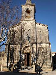
Church | ||
| ||
 Grabels | ||
|
Location within Occitanie region  Grabels | ||
| Coordinates: 43°38′55″N 3°48′09″E / 43.6486°N 3.8025°ECoordinates: 43°38′55″N 3°48′09″E / 43.6486°N 3.8025°E | ||
| Country | France | |
| Region | Occitanie | |
| Department | Hérault | |
| Arrondissement | Montpellier | |
| Canton | Montpellier-10 | |
| Intercommunality | Montpellier | |
| Government | ||
| • Mayor (2008-2014) | René Revol (PG) | |
| Area1 | 16.24 km2 (6.27 sq mi) | |
| Population (2008)2 | 6,092 | |
| • Density | 380/km2 (970/sq mi) | |
| Time zone | CET (UTC+1) | |
| • Summer (DST) | CEST (UTC+2) | |
| INSEE/Postal code | 34116 / 34790 | |
| Elevation |
50–167 m (164–548 ft) (avg. 68 m or 223 ft) | |
|
1 French Land Register data, which excludes lakes, ponds, glaciers > 1 km² (0.386 sq mi or 247 acres) and river estuaries. 2 Population without double counting: residents of multiple communes (e.g., students and military personnel) only counted once. | ||
.svg.png)
Grabels is a commune in the Hérault département in the Occitanie region in southern France.
Population
| Historical population | ||
|---|---|---|
| Year | Pop. | ±% |
| 1962 | 835 | — |
| 1968 | 1,020 | +22.2% |
| 1975 | 1,537 | +50.7% |
| 1982 | 2,527 | +64.4% |
| 1990 | 3,130 | +23.9% |
| 1999 | 5,438 | +73.7% |
| 2008 | 6,092 | +12.0% |
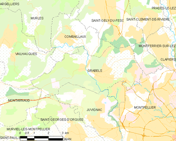
Map
See also
References
| Wikimedia Commons has media related to Grabels. |
This article is issued from Wikipedia - version of the 11/12/2016. The text is available under the Creative Commons Attribution/Share Alike but additional terms may apply for the media files.