Saint-Jean-de-Minervois
| Saint-Jean-de-Minervois | ||
|---|---|---|
|
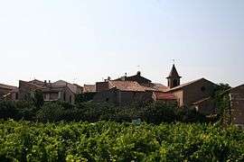
A general view of Saint-Jean-de-Minervois | ||
| ||
 Saint-Jean-de-Minervois | ||
|
Location within Occitanie region  Saint-Jean-de-Minervois | ||
| Coordinates: 43°23′14″N 2°50′00″E / 43.3872°N 2.8333°ECoordinates: 43°23′14″N 2°50′00″E / 43.3872°N 2.8333°E | ||
| Country | France | |
| Region | Occitanie | |
| Department | Hérault | |
| Arrondissement | Béziers | |
| Canton | Saint-Pons-de-Thomières | |
| Intercommunality | Pays Saint-Ponais | |
| Government | ||
| • Mayor (2008–2014) | Francis Barthes | |
| Area1 | 32.7 km2 (12.6 sq mi) | |
| Population (2008)2 | 139 | |
| • Density | 4.3/km2 (11/sq mi) | |
| Time zone | CET (UTC+1) | |
| • Summer (DST) | CEST (UTC+2) | |
| INSEE/Postal code | 34269 / 34360 | |
| Elevation |
159–778 m (522–2,552 ft) (avg. 280 m or 920 ft) | |
|
1 French Land Register data, which excludes lakes, ponds, glaciers > 1 km² (0.386 sq mi or 247 acres) and river estuaries. 2 Population without double counting: residents of multiple communes (e.g., students and military personnel) only counted once. | ||
.svg.png)
Saint-Jean-de-Minervois is a commune in the Hérault department in the Occitanie region in southern France.
When it was created in 1908, this commune's name was Saint-Jean-de-Pardailhan.
Its name was changed in 1936 to allow a better marketing of its famous muscat wine, the Muscat de Saint-Jean-de-Minervois, recognized since 1949.
Population
| Historical population | ||
|---|---|---|
| Year | Pop. | ±% |
| 1962 | 164 | — |
| 1968 | 182 | +11.0% |
| 1975 | 151 | −17.0% |
| 1982 | 146 | −3.3% |
| 1990 | 135 | −7.5% |
| 1999 | 115 | −14.8% |
| 2008 | 139 | +20.9% |
See also
References
| Wikimedia Commons has media related to Saint-Jean-de-Minervois. |
This article is issued from Wikipedia - version of the 11/12/2016. The text is available under the Creative Commons Attribution/Share Alike but additional terms may apply for the media files.